Difference between revisions of "2024-09-01 55 11"
Coyotebush (talk | contribs) ([live picture]Selfie west [https://openstreetmap.org/?mlat=55.44004444&mlon=11.67026667&zoom=16 @55.4400,11.6703]) |
Coyotebush (talk | contribs) (story) |
||
| Line 9: | Line 9: | ||
-->{{meetup graticule|date=2024-09-01|lat=55|lon=11}} | -->{{meetup graticule|date=2024-09-01|lat=55|lon=11}} | ||
== Location == | == Location == | ||
| − | + | Along the main street in Fjenneslev. | |
== Participants == | == Participants == | ||
| − | + | ||
| − | + | [[User:coyotebush|coyotebush]] | |
== Plans == | == Plans == | ||
| − | + | While riding a train from Hamburg to Copenhagen, I re-checked the hashpoints and realized this one was actually reachable. Even better, it wasn't far from the Ringsted station, my train's penultimate stop (and only about 200 meters from the tracks; Fjenneslev no longer has an active station). | |
| + | |||
| + | Typically I've been cycling to hashes during travel detours like this. Today's weather was pleasant for cycling, and infrastructure in Denmark would probably be fine. But Ringsted to Fjenneslev and back is slightly farther than I typically like to ride. Google Maps suggested bus 460R would be much faster - it only runs once an hour each direction, but was perfectly timed to give me a few minutes in Ringsted and about 30 minutes in Fjenneslev. I figured if I cycled, the bus would probably pass me both ways. Since my Brompton wouldn't be any use, I planned to lock it up in Ringsted. | ||
| + | |||
| + | Then after, I could pick among frequent trains continuing from Ringsted to Copenhagen. | ||
== Expedition == | == Expedition == | ||
| − | + | Once my train left Odense on time, I looked into getting a bus ticket. I eventually figured out that Danish bus tickets are good for unlimited travel within an hour or so in their valid zones, so a single ticket (24 DKK) would get me both there and back. | |
| − | + | Hurried through the Ringsted station until I found the bike parking out front and the bus waiting nearby. Locked bike, boarded bus and flashed the ticket at the driver. Quick ride, and wasn't the only one getting off at Thyrasvej. Crossed road, continued walking another 50 meters until I was at the point. | |
| − | + | ||
| + | Then a wait, also not alone, for the return bus. Retrieved bike. Caught a regional train onward, which also conveniently brought me closer to my final destination. | ||
== Photos == | == Photos == | ||
| Line 36: | Line 41: | ||
Image:2024-09-01_55_11_coyotebush_1725197331015.jpg|Map screenshot | Image:2024-09-01_55_11_coyotebush_1725197331015.jpg|Map screenshot | ||
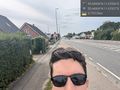
| − | Image:2024-09-01_55_11_coyotebush_1725197617293.jpg|Selfie east [https://openstreetmap.org/?mlat=55.44004444&mlon=11.67026667&zoom=16 @55.4400,11.6703] | + | Image:2024-09-01_55_11_coyotebush_1725197617293.jpg|Selfie east (yellow signs mark the bus stops) [https://openstreetmap.org/?mlat=55.44004444&mlon=11.67026667&zoom=16 @55.4400,11.6703] |
Image:2024-09-01_55_11_coyotebush_1725197642252.jpg|Selfie west [https://openstreetmap.org/?mlat=55.44004444&mlon=11.67026667&zoom=16 @55.4400,11.6703] | Image:2024-09-01_55_11_coyotebush_1725197642252.jpg|Selfie west [https://openstreetmap.org/?mlat=55.44004444&mlon=11.67026667&zoom=16 @55.4400,11.6703] | ||
| Line 43: | Line 48: | ||
== Achievements == | == Achievements == | ||
{{#vardefine:ribbonwidth|100%}} | {{#vardefine:ribbonwidth|100%}} | ||
| − | + | {{Public transport geohash | latitude = 55 | longitude = 11 | date = 2024-09-01 | name = coyotebush | image = 2024-09-01_55_11_coyotebush_1725197049105.jpg}} | |
__NOTOC__ | __NOTOC__ | ||
| − | |||
| − | |||
| − | |||
| − | |||
| − | |||
| − | |||
| − | |||
| − | |||
| − | |||
| − | |||
[[Category:Expeditions]] | [[Category:Expeditions]] | ||
| − | |||
[[Category:Expeditions with photos]] | [[Category:Expeditions with photos]] | ||
| − | |||
| − | |||
| − | |||
[[Category:Coordinates reached]] | [[Category:Coordinates reached]] | ||
| − | |||
| − | |||
| − | |||
| − | |||
| − | |||
| − | |||
| − | |||
| − | |||
| − | |||
| − | |||
| − | |||
| − | |||
| − | |||
| − | |||
Revision as of 18:41, 1 September 2024
| Sun 1 Sep 2024 in 55,11: 55.4400774, 11.6702574 geohashing.info google osm bing/os kml crox |
Location
Along the main street in Fjenneslev.
Participants
Plans
While riding a train from Hamburg to Copenhagen, I re-checked the hashpoints and realized this one was actually reachable. Even better, it wasn't far from the Ringsted station, my train's penultimate stop (and only about 200 meters from the tracks; Fjenneslev no longer has an active station).
Typically I've been cycling to hashes during travel detours like this. Today's weather was pleasant for cycling, and infrastructure in Denmark would probably be fine. But Ringsted to Fjenneslev and back is slightly farther than I typically like to ride. Google Maps suggested bus 460R would be much faster - it only runs once an hour each direction, but was perfectly timed to give me a few minutes in Ringsted and about 30 minutes in Fjenneslev. I figured if I cycled, the bus would probably pass me both ways. Since my Brompton wouldn't be any use, I planned to lock it up in Ringsted.
Then after, I could pick among frequent trains continuing from Ringsted to Copenhagen.
Expedition
Once my train left Odense on time, I looked into getting a bus ticket. I eventually figured out that Danish bus tickets are good for unlimited travel within an hour or so in their valid zones, so a single ticket (24 DKK) would get me both there and back.
Hurried through the Ringsted station until I found the bike parking out front and the bus waiting nearby. Locked bike, boarded bus and flashed the ticket at the driver. Quick ride, and wasn't the only one getting off at Thyrasvej. Crossed road, continued walking another 50 meters until I was at the point.
Then a wait, also not alone, for the return bus. Retrieved bike. Caught a regional train onward, which also conveniently brought me closer to my final destination.
Photos
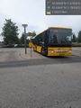
Bus waiting in Ringsted @55.4384,11.7853
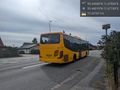
Goodbye bus @55.4402,11.6714
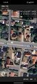
Map screenshot
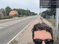
Selfie east (yellow signs mark the bus stops) @55.4400,11.6703
Selfie west @55.4400,11.6703


Achievements
coyotebush earned the Public transport geohash achievement
|