Difference between revisions of "2024-09-15 27 -81"
(text) |
(all the rest (now to see if popular opinion decides yes)) |
||
| Line 29: | Line 29: | ||
<!-- 10d100h: not a tracklog either --> | <!-- 10d100h: not a tracklog either --> | ||
| + | |||
== Photos == | == Photos == | ||
| − | |||
| − | |||
| − | |||
<gallery perrow="5"> | <gallery perrow="5"> | ||
| + | Image:2024-09-15_27_-81_IMG_0257.PNG | Reading on Compass, in DMS format | ||
| + | Image:2024-09-15_27_-81_P1200537.JPG | Blurry shot of Compass | ||
| + | Image:2024-09-15_27_-81_P1200539.JPG | Ground | ||
| + | Image:2024-09-15_27_-81_P1200540.JPG | This mailbox was important | ||
| + | Image:2024-09-15_27_-81_P1200541.JPG | So was this tree (it's how I knew I was there) | ||
</gallery> | </gallery> | ||
== Achievements == | == Achievements == | ||
{{#vardefine:ribbonwidth|100%}} | {{#vardefine:ribbonwidth|100%}} | ||
| − | + | {{Land geohash|latitude=27|longitude=-81|date=2024-09-15|name=[[User:10d100h|10d100h]]}} | |
| + | (just this once...) | ||
__NOTOC__ | __NOTOC__ | ||
| − | |||
| − | |||
| − | |||
| − | |||
| − | |||
| − | |||
| − | |||
| − | |||
| − | |||
| − | |||
[[Category:Expeditions]] | [[Category:Expeditions]] | ||
| − | |||
[[Category:Expeditions with photos]] | [[Category:Expeditions with photos]] | ||
| − | |||
| − | |||
| − | |||
| − | |||
[[Category:Coordinates reached]] | [[Category:Coordinates reached]] | ||
| − | |||
| − | |||
| − | |||
| − | |||
| − | |||
| − | |||
| − | |||
| − | |||
| − | |||
| − | |||
| − | |||
| − | |||
| − | |||
| − | |||
Revision as of 01:38, 16 September 2024
| Sun 15 Sep 2024 in 27,-81: 27.9435660, -81.9466165 geohashing.info google osm bing/os kml crox |
Location
Next to a tree on Trace Pl, south of Lakeland, FL
Participants
Expedition
I'm a little surprised I pulled this off given the circumstances, but hey, I did it.
Having found this location out on Friday, I've anticipated going here, because out of the 3 days this seemed to be the most reasonable point. However, I've never actually been to Lakeland before; probably bypassed it on the numerous occasions I went to Orlando, but not there for any specific reason. I was anxiously waiting to head off all day; someone took the crossover out to a party the previous night, and didn't come back until 7 pm. A bit scary to me because at any rate beyond 10 miles, it means I arrive home by dark or nearly, and this was probably the first time I've been alone in the dark. I didn't want to prepare for this reason also; I would've used a camcorder to record the trip, but I wanted to get to, get from as soon as possible.
On to the journey: I rolled the crossover out of the garage and went on my way. First, it was out of the suburbs, then onto Lithia Pinecrest Road, which turned into CR 640; I've never been there, and I was thinking of driving all the way to FL-37 a few days ago, but decided to stop at the bounds of familiar territory, which is basically still Lithia Pinecrest. CR 640 was the longest, but there isn't much I can say about it; noteworthy only is that a semi truck pulled in front of me, and not long later was a railroad crossing. A full stop is what it means. Otherwise, I had the cruise control set faster than normal to make sure I didn't arrive home at 21:30, and CR 640 reminds me of the Midwest; it might as well be.
Upon FL-37, left there, where sooner than I thought a town popped up; now I knew I was getting close to Lakeland proper. Then more fast highway until right onto Carter Road, which contains the road the hashpoint is located on; Trace Pl. (Trace Place, or Trace Plaza?)
Approaching the point, it was a bit unreal knowing I was looking at the same thing I've looked at on Street View the whole day. Stress had built up at this point, but a short minute was all it took to begin the approach. I wanted to leave the car's headlights on, but I figured to take the key so the keyless crossover wouldn't complain out loud. This meant the headlights turned off after a short bit.
I didn't prepare for the photos either; I set my ZS70 to manual focus and didn't bother to adjust because I didn't want the nearby house's lights to brighten up severely, so the photos are blurry, sorry :( However, checking my iPhone's Compass, the DMS was close to what it read on Google Earth, so I think I achieved it; otherwise I might've crossed the uncertainly circle anyway.
Knowing this, I immediately headed home. Much the same as the forward trip, except I passed a pickup on CR 640; quite risky, but I figured to do it because there weren't any bright lights uncomfortably approaching. When I got back to familiar territory, I slowed down because cutting 2 minutes to home wasn't really necessary at this point.
Back at home, my relatives were wondering why I went to Lakeland. They know about geohashing (in fact one of them introduced me to it), but they seem to have completely forgotten about it.
Now, at this stage, I could be a regular passerby and quit this whole thing entirely; one expedition is good enough for most people, I've noticed. Having gotten a taste of it, however... it compels me to do more. =)
Photos
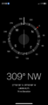
Reading on Compass, in DMS format
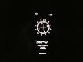
Blurry shot of Compass
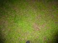
Ground
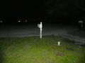
This mailbox was important
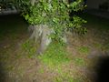
So was this tree (it's how I knew I was there)


Achievements
10d100h earned the Land geohash achievement
|
(just this once...)