Difference between revisions of "2024-09-02 35 -78"
| Line 1: | Line 1: | ||
| − | + | {{meetup graticule|date=2024-09-02|lat=35|lon=-78}} | |
| − | |||
| − | |||
| − | |||
| − | |||
| − | |||
| − | |||
| − | |||
| − | |||
== Location == | == Location == | ||
| − | |||
Durant Nature Preserve in Raleigh, North Carolina, United States | Durant Nature Preserve in Raleigh, North Carolina, United States | ||
== Participants == | == Participants == | ||
| − | + | *[[User:KCMS|KCMS]] | |
| − | |||
| − | [[User:KCMS|KCMS]] | ||
== Plans == | == Plans == | ||
| − | |||
I had heard about geohashing many years ago on xkcd but had never ended up doing it. I recently remembered this activity and decided to give it a try. I downloaded the app on Friday, and due to the three-day weekend for Labor Day, there were four days of geohashes visible. I figured that of these, I was most likely to try this one (Monday's), as it was geographically the closest to me, was in a nature preserve I'd never been to, and was close to a trail. I ended up deciding to find it, coupled with some birdwatching. | I had heard about geohashing many years ago on xkcd but had never ended up doing it. I recently remembered this activity and decided to give it a try. I downloaded the app on Friday, and due to the three-day weekend for Labor Day, there were four days of geohashes visible. I figured that of these, I was most likely to try this one (Monday's), as it was geographically the closest to me, was in a nature preserve I'd never been to, and was close to a trail. I ended up deciding to find it, coupled with some birdwatching. | ||
== Expedition == | == Expedition == | ||
| − | |||
I drove to the parking lot for Durant Nature Preserve. It is a forested area with a couple lakes and some streams. I didn't see as many birds as I had hoped to, but there were a few, the highlight of which was a great blue heron. I followed the trails to get as close as I could to the geohash, which was about 100 feet off the trail. That area had a lot of pine trees and minimal undergrowth, so it was pretty easy to walk through. I wandered around trying to minimize the distance to the geohash until the app told me I was within the accuracy margin of error. I took a few pictures and continued the hike. | I drove to the parking lot for Durant Nature Preserve. It is a forested area with a couple lakes and some streams. I didn't see as many birds as I had hoped to, but there were a few, the highlight of which was a great blue heron. I followed the trails to get as close as I could to the geohash, which was about 100 feet off the trail. That area had a lot of pine trees and minimal undergrowth, so it was pretty easy to walk through. I wandered around trying to minimize the distance to the geohash until the app told me I was within the accuracy margin of error. I took a few pictures and continued the hike. | ||
| − | |||
| − | |||
| − | |||
== Photos == | == Photos == | ||
| − | |||
| − | |||
| − | |||
<gallery perrow="5"> | <gallery perrow="5"> | ||
| − | + | File:2024-09-02 35 -78 KCMS 1725317205403.jpg|First ever Geohash! [https://openstreetmap.org/?mlat=35.89070497&mlon=-78.58971597&zoom=16 @35.8907,-78.5897] | |
| − | |||
File:2024-09-02 35 -78 KCMS 2.jpg|View from geohash | File:2024-09-02 35 -78 KCMS 2.jpg|View from geohash | ||
File:2024-09-02 35 -78 KCMS 3.jpg|View from geohash | File:2024-09-02 35 -78 KCMS 3.jpg|View from geohash | ||
| Line 42: | Line 22: | ||
File:2024-09-02 35 -78 KCMS 7.png|App screenshot at geohash | File:2024-09-02 35 -78 KCMS 7.png|App screenshot at geohash | ||
</gallery> | </gallery> | ||
| + | |||
== Achievements == | == Achievements == | ||
{{#vardefine:ribbonwidth|100%}} | {{#vardefine:ribbonwidth|100%}} | ||
| − | |||
{{land geohash | latitude = 35 | longitude = -78 | date = 2024-09-02 | name = [[User:KCMS|KCMS]] }} | {{land geohash | latitude = 35 | longitude = -78 | date = 2024-09-02 | name = [[User:KCMS|KCMS]] }} | ||
| + | |||
__NOTOC__ | __NOTOC__ | ||
| − | + | [[Category:Expeditions]] | |
| − | |||
| − | [[Category: | ||
[[Category:Coordinates reached]] | [[Category:Coordinates reached]] | ||
[[Category:Expeditions with photos]] | [[Category:Expeditions with photos]] | ||
| − | |||
| − | |||
| − | |||
| − | |||
| − | |||
| − | |||
| − | |||
| − | |||
| − | |||
| − | |||
| − | |||
| − | |||
| − | |||
| − | |||
| − | |||
| − | |||
| − | |||
| − | |||
| − | |||
| − | |||
| − | |||
| − | |||
| − | |||
| − | |||
| − | |||
| − | |||
| − | |||
| − | |||
| − | |||
Revision as of 20:23, 23 September 2024
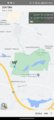
| Mon 2 Sep 2024 in 35,-78: 35.8906776, -78.5897212 geohashing.info google osm bing/os kml crox |
Location
Durant Nature Preserve in Raleigh, North Carolina, United States
Participants
Plans
I had heard about geohashing many years ago on xkcd but had never ended up doing it. I recently remembered this activity and decided to give it a try. I downloaded the app on Friday, and due to the three-day weekend for Labor Day, there were four days of geohashes visible. I figured that of these, I was most likely to try this one (Monday's), as it was geographically the closest to me, was in a nature preserve I'd never been to, and was close to a trail. I ended up deciding to find it, coupled with some birdwatching.
Expedition
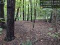
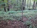
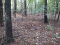
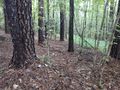
I drove to the parking lot for Durant Nature Preserve. It is a forested area with a couple lakes and some streams. I didn't see as many birds as I had hoped to, but there were a few, the highlight of which was a great blue heron. I followed the trails to get as close as I could to the geohash, which was about 100 feet off the trail. That area had a lot of pine trees and minimal undergrowth, so it was pretty easy to walk through. I wandered around trying to minimize the distance to the geohash until the app told me I was within the accuracy margin of error. I took a few pictures and continued the hike.
Photos
First ever Geohash! @35.8907,-78.5897
View from geohash
View from geohash
View from geohash
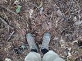
My boots at the geohash
App screenshot at geohash
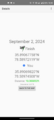
App screenshot at geohash


Achievements
KCMS earned the Land geohash achievement
|