Difference between revisions of "2024-09-23 40 -112"
m (Location) |
(added expedition log, images, and acheivements) |
||
| Line 15: | Line 15: | ||
== Plans == | == Plans == | ||
I plan to head out here today. It's like a 50 minute bike ride from my house, but that should be fine. Hopefully no one will run me over on the highway - [[User:W1THRD|W1THRD]] (15:52 Sep 24, 2024) | I plan to head out here today. It's like a 50 minute bike ride from my house, but that should be fine. Hopefully no one will run me over on the highway - [[User:W1THRD|W1THRD]] (15:52 Sep 24, 2024) | ||
| + | |||
| + | == Expedition == | ||
| + | I rode my bike through a park, crossed over to Old Bingham Highway, and began to ride on the side of the road. It was really scary, and I kept on having to ride in the gravel to avoid being run over. I had to cross Mountain View Corridor, which will become a freeway sometime in the future. Along the way to my destination, I passed a massive Amazon warehouse and a random deer carcass on the side of the road! Wonderful!!! | ||
| + | |||
| + | Overall, that 12.3 mile bike ride was really crazy, I don't think I'll do that again. | ||
== Photos == | == Photos == | ||
| Line 20: | Line 25: | ||
<gallery> | <gallery> | ||
2024-09-23 40 -112 gmaps.png|location of the geohash | 2024-09-23 40 -112 gmaps.png|location of the geohash | ||
| + | 2024-09-23 40 -112 warehouse.jpg|massive Amazon warehouse | ||
| + | 2024-09-23 40 -112 copperton.jpg|Welcome to Copperton!!! | ||
| + | 2024-09-23_40_-112_reached1.jpg|I made it!!! | ||
</gallery> | </gallery> | ||
| + | |||
| + | == Achievements == | ||
| + | |||
| + | {{bicycle geohash | ||
| + | |date=2024-09-23 | ||
| + | |latitude=40 | ||
| + | |longitude=-112 | ||
| + | |name=[[User:W1THRD|W1THRD]] | ||
| + | |distance=19.84 km | ||
| + | |bothways= true | ||
| + | |image=2024-09-23_40_-112_reached1.jpg | ||
| + | }} | ||
| + | {{land geohash | ||
| + | |date=2024-09-23 | ||
| + | |latitude=40 | ||
| + | |longitude=-112 | ||
| + | |name=[[User:W1THRD|W1THRD]] | ||
| + | |image=2024-09-23_40_-112_reached1.jpg | ||
| + | }} | ||
| + | {{No_batteries_geohash | latitude = 40 | longitude = -112 | date = 2024-09-23 | name = W1THRD | image = 2024-09-23_40_-112_reached1.jpg}} | ||
[[Category:Expedition planning]] | [[Category:Expedition planning]] | ||
{{location|US|UT|SL}} | {{location|US|UT|SL}} | ||
Revision as of 23:18, 23 September 2024
| Mon 23 Sep 2024 in 40,-112: 40.5674531, -112.0955456 geohashing.info google osm bing/os kml crox |
Location
Out in a natural area, at the dead end of Solstice View Drive, in Coppeton, Utah
Participants
Plans
I plan to head out here today. It's like a 50 minute bike ride from my house, but that should be fine. Hopefully no one will run me over on the highway - W1THRD (15:52 Sep 24, 2024)
Expedition
I rode my bike through a park, crossed over to Old Bingham Highway, and began to ride on the side of the road. It was really scary, and I kept on having to ride in the gravel to avoid being run over. I had to cross Mountain View Corridor, which will become a freeway sometime in the future. Along the way to my destination, I passed a massive Amazon warehouse and a random deer carcass on the side of the road! Wonderful!!!
Overall, that 12.3 mile bike ride was really crazy, I don't think I'll do that again.
Photos
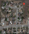
location of the geohash
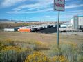
massive Amazon warehouse
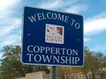
Welcome to Copperton!!!
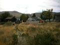
I made it!!!


Achievements
W1THRD earned the Bicycle geohash achievement
|
W1THRD earned the Land geohash achievement
|
W1THRD earned the No Batteries Geohash Achievement
|