Difference between revisions of "2024-10-17 47 8"
From Geohashing
m (Location) |
Globescorer (talk | contribs) (→Achievements) |
||
| Line 29: | Line 29: | ||
{{#vardefine:ribbonwidth|100%}} | {{#vardefine:ribbonwidth|100%}} | ||
{{land geohash|date=2024-10-17|latitude=47|longitude=8|name=[[User:globescorer|globescorer]]|image=2024-10-17 The Geohash.jpg}} | {{land geohash|date=2024-10-17|latitude=47|longitude=8|name=[[User:globescorer|globescorer]]|image=2024-10-17 The Geohash.jpg}} | ||
| + | {{consecutive geohash 2 | count = 2 | latitude = 47 | longitude = 8 | date = 2024-10-16 | name = globescorer }} | ||
{{location|CH|ZH}} | {{location|CH|ZH}} | ||
Revision as of 14:11, 18 October 2024
Location
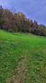
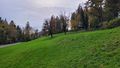
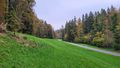
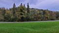
This Geohash is located in a meadow near Oberembrach.
Participants
Plans
Visiting this geohash after work on the way home.
Expedition
In contrast to yesterday's geohash, this one should be a solid one. Simply park your motorcycle on a minimal detour nearby shortly after work and walk about four minutes. First a few meters on the road, then on the meadow to the coordinates. After a few photos I was gone again...
Photos

way to go 1
way to go 2

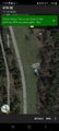
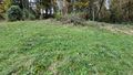
the geohash

proof 1
proof 2
north
east
south
west


Achievements
globescorer earned the Land geohash achievement
|
globescorer earned the Consecutive geohash achievement
|