Difference between revisions of "2024-10-21 53 7"
Beardygrade (talk | contribs) (→Expedition) |
Beardygrade (talk | contribs) (→Expedition) |
||
| Line 20: | Line 20: | ||
<!-- how it all turned out. your narrative goes here. --> | <!-- how it all turned out. your narrative goes here. --> | ||
Since I had a work meeting in [https://en.wikipedia.org/wiki/Wilhelmshaven Wilhelmshaven], somewhat about 20 km from the geohash, I decided to bring my bike on the train and try to make it to the geohash after work. I also looked forward to cycling to the meeting instead of using the bus. Of course, somehow I got lost on the strets of Wilhelmshaven and almost didn't make it in time to the meeting. | Since I had a work meeting in [https://en.wikipedia.org/wiki/Wilhelmshaven Wilhelmshaven], somewhat about 20 km from the geohash, I decided to bring my bike on the train and try to make it to the geohash after work. I also looked forward to cycling to the meeting instead of using the bus. Of course, somehow I got lost on the strets of Wilhelmshaven and almost didn't make it in time to the meeting. | ||
| − | Afterwards, I started cycling toward Wittmund, using roadside signs for navigation which are quite helpful. At day. To be honest, | + | |
| + | Afterwards, I started cycling toward Wittmund, using roadside signs for navigation which are quite helpful. At day. To be honest, this particular day had been overcast and never got very bright. But shortly after I started, it got more and more dark. Since these bicycle path signs are smaller than the signs for cars, are installed 2 m above the ground and often rather off-center, chances are very small that your average bicycle light will fall on them. In consequence, I ended up stopping at crossings and looking for the signs, until I switched to smartphone navigation. Which still meant having to stop every so often. But nevertheless, one of these signs directed me towards a small street called [https://www.schortens.de/portal/seiten/die-langsamstrasse-900000185-20840.html Langsamstrasse] - "slow street". It is a street crossing mostly farm land and forest and on every corner there is a place to sit, a piece of art, or another interesting station. In the waning light, I only made a picture of the tall flowers. | ||
| + | |||
| + | Some time later, I passed the brewery of [https://en.wikipedia.org/wiki/Jever_Brewery Jever] in the town [https://en.wikipedia.org/wiki/Jever Jever]. The last few kilometers were on a street without any lanterns and it was really dark by this time. But I managed to stay on the (otherwise empty) roads and found the spot without any problems. | ||
== Tracklog == | == Tracklog == | ||
Revision as of 16:42, 28 October 2024
| Mon 21 Oct 2024 in 53,7: 53.5524475, 7.7872750 geohashing.info google osm bing/os kml crox |
Location
A road in Klein Isums, south of Wittmund. Actually, the name of the road is "Isums" as well.
Participants
Expedition
Since I had a work meeting in Wilhelmshaven, somewhat about 20 km from the geohash, I decided to bring my bike on the train and try to make it to the geohash after work. I also looked forward to cycling to the meeting instead of using the bus. Of course, somehow I got lost on the strets of Wilhelmshaven and almost didn't make it in time to the meeting.
Afterwards, I started cycling toward Wittmund, using roadside signs for navigation which are quite helpful. At day. To be honest, this particular day had been overcast and never got very bright. But shortly after I started, it got more and more dark. Since these bicycle path signs are smaller than the signs for cars, are installed 2 m above the ground and often rather off-center, chances are very small that your average bicycle light will fall on them. In consequence, I ended up stopping at crossings and looking for the signs, until I switched to smartphone navigation. Which still meant having to stop every so often. But nevertheless, one of these signs directed me towards a small street called Langsamstrasse - "slow street". It is a street crossing mostly farm land and forest and on every corner there is a place to sit, a piece of art, or another interesting station. In the waning light, I only made a picture of the tall flowers.
Some time later, I passed the brewery of Jever in the town Jever. The last few kilometers were on a street without any lanterns and it was really dark by this time. But I managed to stay on the (otherwise empty) roads and found the spot without any problems.
Tracklog
The bicycle part of the journey.

Photos
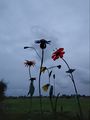
Flower sculptures along slow street.

Proof. @53.5524,7.7873
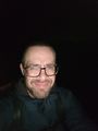
Stupid grin at night. @53.5356,7.7817


Achievements