2009-09-18 49 9
| Fri 18 Sep 2009 in Würzburg: 49.9523530, 9.9190686 geohashing.info google osm bing/os kml crox |
Location
Today's location is in the forest near Arnstein's boroughs Müdesheim and Halsheim.
Country: Germany; state: Bayern (Bavaria, EU:DE:BY); administrative region: Unterfranken; district: Main-Spessart
Expedition
User:thepiguy
Heading out right after work I had high hopes of getting back before dark. I took the usual bike rout to Zellingen and then took a right and headed up a gigantic hill towards the hash. The highway ended up being a bit scarier than I had expected and I really hoped I wouldn't have to bike along it in the dark. The roads got progressively smaller until I ended up on a small dirt road less than a kilometer from the coordinates.
I switched to my second GPS and started walking along a small path that lead up a hill next to a forest. A little while later, while still walking, I decided to check my other GPS to see where the nearest road was. It was then I noticed they were pointing me in two very different directions. Oops. I took out the coordinates and found that I was heading to a point one minute of longitude from the geohash. Oops.
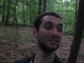
Once back at the bottom of the hill, I headed of in the right direction. This time I ended up in the middle of a very creepy forest. It was 19:05 when I took my pictures at the Geohash. I was going to stay longer but the it was getting dark and the forest was starting to get to me. I even thought I heard someone else walking around!
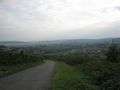
It was loooooonnng.
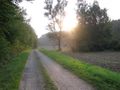
Right before I started off towards the hash... erm... the first time.

At the hash.
"What was that?"
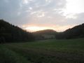
Out of the forest and heading back home.


Danatar
- Tbu.jpg
tbu