2010-03-13 -19 146
From Geohashing
Revision as of 22:42, 12 March 2010 by imported>Mattyk (→Location)
| Sat 13 Mar 2010 in -19,146: -19.8458133, 146.6716763 geohashing.info google osm bing/os kml crox |
Location
- 19° 50' 44.93" S, 146° 40' 18.03" E
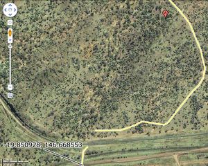
500m off the Flinders Highway, half way to Charters Towers.
Participants
- Matty K and family
Matty K's Plan
Some time this morning we're going to head out that way, and see how it looks. Thanks to Google Maps I've located a potential dirt track that may lead from the highway, cutting 9/10ths of the off-road journey (see image inset); hopefully making it much easier with my 1¾ and 3½ year olds.
Check back in a few hours to see what went down.
