2011-07-20 52 1
From Geohashing
Revision as of 18:25, 20 July 2011 by imported>Sourcerer ([live picture] Corn. [http://www.openstreetmap.org/?lat=52.475064396858215&lon=1.4940977096557617&zoom=16&layers=B000FTF @52.4751,1.4941])
| Wed 20 Jul 2011 in 52,1: 52.4747509, 1.4949577 geohashing.info google osm bing/os kml crox |
Location
Participants
Plans
Expedition
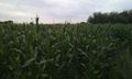
- 70 meters to the hash but tall sweet corn is blocking access. -- Sourcerer @52.4751,1.4941 19:22, 20 July 2011 (GMT+01:00)
Tracklog
Photos
Corn. @52.4751,1.4941

Achievements