2015-09-03 51 0
| Thu 3 Sep 2015 in 51,0: 51.7331961, 0.6424850 geohashing.info google osm bing/os kml crox |
Location
In a field, east of Curling Tye Green, Essex, UK.
Participants
Plans
Sourcerer is visiting east Kent in Canterbury, United Kingdom. This is close to the route. ETA 11 am or perhaps noon.
Expedition
- No access. Ploughing in progress. -- Sourcerer (talk) @51.7329,.6426 12:59, 3 September 2015 (GMT+01:00)
This was not a success. If I'd been an hour earlier, it would have better. The ploughing would not have started and it would have been an easy stubble field. So I decided not to play dodge-the-plough and make the tractor driver angry. I took a photo and left.
Now I'm on the cloud WiFi at the University of Kent at Canterbury re-visiting 40 years after I was a student there. Back in the day, the Internet just about existed with ASCII text only.
Photos

Closest approach. @51.7329,.6426
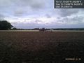
Tractor and plough at hashpoint. @51.7329,.6426


Achievements
Expeditions and Plans
| 2015-09-03 | ||
|---|---|---|
| Portland, Oregon | Michael5000, Jim | On a street in the 60s, just north of the Banfield. |
| Mannheim, Germany | Tads | Almost on top of the Melibokus hill, in a wood close to Alsbach-Hähnlein. |
| London East, United Kingdom | Sourcerer | 2) In a field, east of Curling Tye Green, Essex, UK - placed.smarting.stitching... |
| Norwich, United Kingdom | Sourcerer | 1) erase.buzz.shame = a field south of Horsey Wind pump, Norfolk, UK. |
Sourcerer's Expedition Links
2015-09-03 52 1 - 2015-09-03 51 0 - 2015-09-05 51 1 - KML file download of Sourcerer's expeditions for use with Google Earth.