2009-02-08 67 20
| Sun 8 Feb 2009 in 67,20: 67.7552405, 20.1034115 geohashing.info google osm bing/os kml crox |
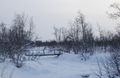
The hash was on a frozen bog (surprise?) near the Nikkaluokta road south of Kiruna, Sweden.
the ru
This hash was quite easy to reach, I only had traverse 600 m on skis. There were two minor obstacles. First, there was a steep slope. Getting down wasn't a problem, but to get back up I had to take my skis off and crawl.
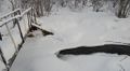
Then, there was a stream. It seemed frozen, but as usual I decided not to risk anything. And as usual, I later discovered that some parts of it were indeed open, so the ice couldn't have been very thick. These streams aren't deep, so there isn't really any risk of drowning - the danger is getting wet and cold, especially at these low temperatures. Getting my skis wet and covered with ice (heavy!) is also a bad idea. And it might not even be possible to recover them from the water.
Anyway, I had plenty of time, so I thought I'd go upstream (which actually turned out to be downstream!) and look for a safe way to cross... and found a bridge!
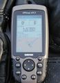
I was hoping to break the cold record and brought a thermometer, but it didn't go below -18.1 C (-18.9 C was the current record).
the ru earned the Land geohash achievement
|
At the hash
- 2009-02-08 67 20 back.jpg
Back at the car - does this qualify as proof for a Frozen Geohash? ;-)
The bridge
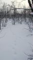
The customary animal tracks


