2009-02-14 51 7
| Sat 14 Feb 2009 in 51,7: 51.8253397, 7.1710255 geohashing.info google osm bing/os kml crox |
Plan
Arvid fell off his bike thursday morning, and therefor needed a new steer. That required a ride to the recumbent shop in Winterswijk (35km one way) and from there the closest hashpoint was 10km closer than from home. I really need to do some longer distances than 100km, and the weather was very nice, so there I went.
The only thing that might have kept me from doing it was the pain in my butt from my fall on thursday. It really hurt and on friday I still felt it. (I still do actually)
Achievements
Expedition
Arvid's tracklog by bicycle.
First I was off to the recumbent shop in Winterswijk, where I fetched my steer. I left home around 11:25 and arrived there around 12:45. Nice weather, little bit of backwind. I planned to leave there at 14:00, or between 14:00 and 14:15. It became 14:30, and I knew that meant I really had to keep the pace up to be at the hash at 16:00.
Just before Reken I missed a turn which led me over a hill. And then back over the hill. At that point I knew it would be highly unlikely to be at the hash at 4pm. And when I saw a clock in Reken that showed 15:47 I knew I wasn't gonna make it. I estimated it would take me about 25 minutes from the edge of Reken to the hash, and that was apparently a very good guess.
The hash itself was, as expected, in a field! It wasn't frozen, as the mud really stuck to my shoes again, but it was cold anyway. The way back didn't go very well, I don't really know what to blame, headwind, hills, my eating habits of the day, or just my general physical state. Anyway, I reached home a bit after 19:00. More exact details when I read out my GPS data.
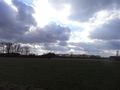
Nice skies.

Sad geohasher because
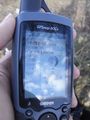
4:15pm

The bike with new steer (in the bag)
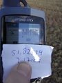
Success!

Happy hasher.
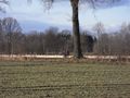
View from the hash to the bike.

Long shadow.
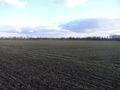
View from the bike to the hashpoint.


