2010-08-15 31 -111
| Sun 15 Aug 2010 in Sasabe: 31.4885295, -111.2567461 geohashing.info google osm bing/os kml crox |
Location
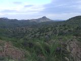
A place of fond memories - Ruby Road between Arivaca and Pena Blanca
Participants
Expeditions
Oops. Once again we start out with a small diversion from the desired track. Seems Wyle didn't reload the GPS after adding the hiking portion to the plan and then mistyped a waypoint. Caught early enough to easily get back on track. The first half mile of hiking ended up being on a trail of sorts along a wash. We encountered discarded backpacks, water jugs and clothes of border crossers all along the way. Once within a tenth of a mile, the bushwacking began. Thats when RoadRunner's son decided to hang back and wait it out while we scrambled a couple ridges over to find the spot. Fortunately, the way out was more direct than the way in because we got to the car with about 10 minutes of twilight to spare. Overall, one of the best and most adventurous outings in quite a while.


