Location
20 m besides Autobahn A4 next to exit Erfurt-Vieselbach.
Participants
Expedition
Manu and Reinhard went sightseeing in Praha this weekend together with Reinhard's mother and her companion and came home on Sunday evening. While approaching Erfurt they passed the hashpoint at a distance of about 20 or 30 m. After Manu and Reinhard had brougt home the other two passengers they turned around towards Jena, passing the hashpoint again at a slightly bigger distance, but this time they took exit Erfurt-Vieselbach to pop around the hashpoint. The satellite picture looked as if one might drive quite close to the hashpoint, but the first path was closed for cars without extra permission and the second one looked too muddy. So they stopped there and walked the 900 remaining meters. After about 700 m they crossed the motorway using a tunnel and then turned left onto some kind of meadow or grassy field where they finally reached the exact coordinates, and as a matter of fact a new hashcot got out of Reinhard's rucksack!
Photos
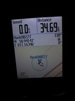
| Coordinates reached. (distance includes 34 km driving)
|
| Sign at the motorway less than 100 m from the hashpoint.
|
|


