2013-01-05 43 -116

| Sat 5 Jan 2013 in 43,-116: 43.8008605, -116.7884382 geohashing.info google osm bing/os kml crox |
Location
Northwest of Caldwell, near the Sand Hollow interchange on I-84
Participants
Plans
I've been wanting to try geohashing for a while, and today things lined up so I had free time, and the geohash looked like it would be accessable.
Expedition
- I'm at the hash point it's really cold so do a full write up when I get back somewhere warm -- Eldin @43.8009,-116.7885 18:36, 5 January 2013 (EST)
- Ok, I'm someplace warmer now, so here's the more complete write-up. The geohash was just off of a narrow dirt road running between an irrigation canal and a plowed field. Missed the dirt road turn off the first time and had to go back. Was able to drive to within 20ft of the geohash location. Arrived at approximately 4:30pm Actual location was about half way down a slippery slope, so while I was able to slide across it, I was actually standing about 12ft away when I took pictures and posted my initial comment while onsite. My phone was both the only camera and only GPS device I had, so I didn't get a picture of the GPS screen. However, the photo of me is geotagged, which serves as the only proof I have that I was in the right place. I've posted the full EXIF information from the photo in lieu of a tracklog, since the metadata displayed on the site doesn't show the actual coordinates from the photo.
Tracklog
File Name : 2013-01-05_16-33-22_671.jpg MIME Type : image/jpeg Exif Byte Order : Little-endian (Intel, II) Make : Motorola Camera Model Name : DROID2 GLOBAL Orientation : Rotate 90 CW X Resolution : 300 Y Resolution : 300 Resolution Unit : inches Software : 2.3.4 Modify Date : 2013:01:05 16:33:20 Y Cb Cr Positioning : Centered Exposure Time : 1/688 F Number : 2.8 Exposure Program : Program AE ISO : 116 Exif Version : 0220 Date/Time Original : 2013:01:05 16:33:20 Create Date : 2013:01:05 16:33:20 Components Configuration : Cb, Y, Cr, Y Compressed Bits Per Pixel : 4 Shutter Speed Value : 1/690 Aperture Value : 2.8 Brightness Value : 7.87109375 Exposure Compensation : 0 Max Aperture Value : 2.8 Subject Distance : 0 m Metering Mode : Center-weighted average Light Source : D75 Flash : Auto, Did not fire Focal Length : 4.0 mm User Comment : Flashpix Version : 0100 Color Space : sRGB Exif Image Width : 2592 Exif Image Height : 1456 Interoperability Index : R98 - DCF basic file (sRGB) Interoperability Version : 0100 Exposure Index : 116 Sensing Method : One-chip color area File Source : Digital Camera Scene Type : Directly photographed Exposure Mode : Auto White Balance : Auto Digital Zoom Ratio : 0 Focal Length In 35mm Format : 30 mm Scene Capture Type : Standard Gain Control : Low gain up Contrast : Normal Saturation : Normal Sharpness : Normal Subject Distance Range : Unknown Image Unique ID : GPS Version ID : 2.2.0.0 GPS Latitude Ref : North GPS Longitude Ref : West GPS Altitude Ref : Above Sea Level GPS Time Stamp : 23:33:16 GPS Map Datum : Unknown GPS Processing Method : Unknown GPS Date Stamp : 2013:01:05 Compression : JPEG (old-style) Thumbnail Offset : 2872 Thumbnail Length : 25111 Image Width : 2592 Image Height : 1456 Encoding Process : Baseline DCT, Huffman coding Bits Per Sample : 8 Color Components : 3 Y Cb Cr Sub Sampling : YCbCr4:2:0 (2 2) Aperture : 2.8 GPS Altitude : 743 m Above Sea Level GPS Date/Time : 2013:01:05 23:33:16Z GPS Latitude : 43 deg 48' 3.00" N GPS Longitude : 116 deg 47' 19.00" W GPS Position : 43 deg 48' 3.00" N, 116 deg 47' 19.00" W Image Size : 2592x1456 Scale Factor To 35 mm Equivalent: 7.5 Shutter Speed : 1/688 Thumbnail Image : (Binary data 25111 bytes, use -b option to extract) Circle Of Confusion : 0.004 mm Field Of View : 61.9 deg Focal Length : 4.0 mm (35 mm equivalent: 30.0 mm) Hyperfocal Distance : 1.43 m Light Value : 12.2
Photos

Me standing in front of the hashpoint.
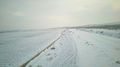
The snow covered single lane dirt road that got me here.


Achievements
Eldin earned the Land geohash achievement
|
Eldin earned the Frozen Geohash Achievement
|