2014-02-06 50 19
From Geohashing
Revision as of 21:12, 6 February 2014 by imported>Mkoniecz (→Photos: File:Mapa.png | OSM map, all data in this image was added by me as part of geohashing activities)

| Thu 6 Feb 2014 in 50,19: 50.0709214, 19.6714825 geohashing.info google osm bing/os kml crox |
Participants
Plans
According to my interpretation of aerial images it should be in orchard, in hamlet called "Zręby". I was worried that it may be inaccessible. I decided to go, as it was in good distance, near a good road and it was perfect target for a cycling trip. I mapped surrounding area on OSM.
Expedition
Cycling was really pleasant, it was the first real trip this year. It turned out that part of orchard disappeared, part never existed (but part turned out to be real). Hashpoint was on a snowy meadow.
Photos
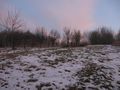
Geohash, closer.
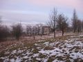
View from geohash.
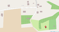
OSM map, all data in this image was added by me as part of geohashing activities


Achievements
Bulwersator earned the Bicycle geohash achievement
|
Bulwersator earned the No Batteries Geohash Achievement
|