2014-06-01 51 13
| Sun 1 Jun 2014 in Dresden: 51.1246731, 13.7440207 geohashing.info google osm bing/os kml crox |
Location
Today's location is on 'Wilschdorfer Landstraße', a 4-lane road in the north of Dresden, near the airport. The spot is in the left lane in eastern direction, next to the 'Rähnitzer Allee' bus stop. Elevation 199 m.
Country: Germany; state: Sachsen (Saxony, EU:DE:SN); district: Dresden; Ortsamt: Klotzsche; statistischer Stadtteil: Hellerau/Wilschdorf
Weather: sunny, some clouds
Expedition
Danatar
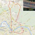
A hashpoint in Dresden, sunny weather, on a Sunday, hooray. I went by bike, starting northwards from my dorm and crossing the Elbe at the Waldschlösschenbrücke. I followed Stauffenbergallee, then turned into Königsbrücker Straße. That one was very long and cycling was a bit difficult because of the pavement. After a while I passed the airport and arrived near the hashpoint. The nearer I came the slower I went because I wanted to do this expedition on a tron route, even though the spot is in the middle of a large road.
I finally crossed the westbound lanes and got to the median strip, where the GPS told me I was 0.00004 degrees from the spot. I waited until there wasn't any traffic, then I went the last meters to the hashpoint, took a picture only 0.00001 degrees off and continued to the other side of the road before any cars came near. Hooray! After taking some pictures I continued my journey, taking a different route homewards. On the way back I cycled through the 'Neustadt' and to the historic center. Next to the Frauenkirche I watched the street artists and listened to a guy playing a grand piano. Then I cycled home, coming from the south in order to close the tron's circle.
Danatar earned the Tron achievement
|
the Fürstenzug, the world's largest porcelain mural
the rebuilt famous Frauenkirche


