User:Pinecone
Pinecone is a Boston based conifer.
An Immodest Proposal
The Issue
A typical hash is about 25 miles away from you. Ramifications of this:
- An long drive each way for those with car.
- Somewhat more problematic for those without.
- On the social front, you meet a lot of nice people but they live far away from you.
- Nobody is ever going to get the damn Couch Potato ribbon.
- You usually get sent to less populated areas:
- Ironic to burn a lot of oil to go see greenery.
- You don't often get to play with cities.
- In populated graticules you have to find a park to hang out in. This is nice for frisbee but less handy for table games.
- In unpopulated graticules most expeditions are less social club and more hiking trip.
- It's a bigger problem for everyone in the winter.
Reasons I might like something nearer at hand:
- Lacking transport
- Want a local group to socialize with
- Want to play with cities
- The regular hash is someplace god-awful
- I am feeling lazy
Obviously we could just divide up the graticules into smaller pieces, but this would scatter the children of XKCD far and wide. I present a solution here that I think can address these issues.
Decicules and Driving Directions
- Divide each graticule into tenths called decicules. For example, if I live in graticule (42,-71) then some decicules near me are
| (42.0,-71.0) | (42.0,-71.1) | (42.0,-71.2) | ... | |
| (42.1,-71.0) | (42.1,-71.1) | (42.1,-71.2) | ... | |
| (42.2,-71.0) | (42.2,-71.1) | (42.2,-71.2) | ... | |
| etc. |
- The day's hash for your graticule will define 10x10 = 100 decihashes which match the hash coordinates except for varying in their tenths digits. For example, if the hash is (42.1357,-71.2468) then some decihashes in that graticule are
| (42.0357,-71.0468) | (42.0357,-71.1468) | (42.0357,-71.2468) | ... | |
| (42.1357,-71.0468) | (42.1357,-71.1468) | (42.1357,-71.2468) | ... | |
| (42.2357,-71.0468) | (42.2357,-71.1468) | (42.2357,-71.2468) | ... | |
| etc. |
- Pick the urban center you are closest to. There will be four decihashes surrounding that location. For example, if I am near Boston the layout would be
| (42.4357,-71.1468) | (42.4357,-71.0468) | |
| Boston | ||
|---|---|---|
| (42.3357,-71.1468) | (42.3357,-71.0468) | |
- Use Google Directions to find which of these decihashes has the shortest driving distance from "Boston".
- The end point for that set of driving directions is the "Boston decihash" for today.
The reason for that last point is to solve an additional problem. When a hash location is inaccessible, people can have confusion about where to meet up. When you give Google Directions an inaccessible destination, it gets as close as it can using public roads. So that endpoint will always be unique and accessible.
The chosen decihash will generally be within 6 miles of the city center. It doesn't matter where Google Maps thinks "Boston" is, or that you won't be driving the route it finds. What matters is that it's consistent for everyone who checks it.
An Example
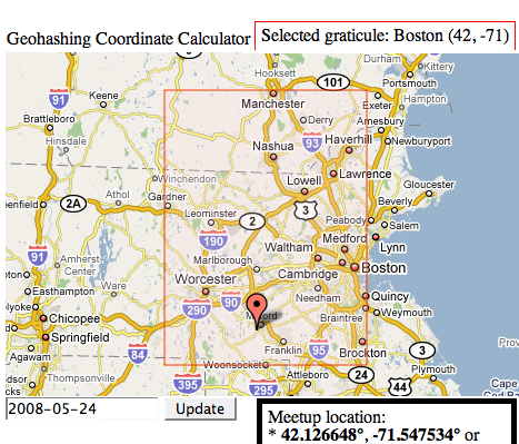
| On 5-24-08 the (42,-71) meet up was at 42.126648,-71.547534: | Meanwhile, back in Boston: |
So in this case, those who are able go to the graticule hash in Hopedale, MA while those more local could meet up at 695 William J Day Blvd, Boston which is where the driving directions for the winning decihash finish. If you have plans to visit a particular decihash, best to mention it on the graticule wiki page ahead of time.
In a graticule with high population there might be several active decicules. Around here one would expect Boston, Worcester, and Nashua to have their own contingents. These decihash meet ups would likely be overridden if the graticule hash itself were nearby.
Honest, this is less complicated than it sounds and an implementation will help. You really only need this for urban areas were population density makes submeet ups feasible.
Notes
Naming conventions: boston grat, bost dec
You can use any location. the Boston decicule will sometimes go to then same location as a Brookline decicule, sometimes not. only if a lot of people.
If the decihash is going to suck, you can pick the location with the 2nd shortest driving distance instead. You would name these decihash locations as: Boston1, Boston2, Boston3, etc.
A decihash can be used as a fall-back for everyone if the graticule hash is going to suck. Hence "Today's graticule hash is in the middle of a swamp but Boston3 is in the hardware department at Sears. Let's go there!"
During weekdays I'm unlikely to be able to road trip to a graticule hash, but it would be great to meet people at Boston1 at say, 8pm.
Pick up more people who generally don't go on road trips for any of the above reasons.
All this is not meant to detract from the preeminence of the original meet up system. Long live the mighty graticule!
Issues
Boundary question: do you use a neighboring graticule to get the closest decihash?
The "dangerous part of town" problem.

