2015-06-24 52 1
From Geohashing
Revision as of 21:50, 24 June 2015 by imported>Sourcerer ([live picture] Proof. [http://www.openstreetmap.org/?lat=52.34914541&lon=1.35032058&zoom=16&layers=B000FTF @52.3491,1.3503])
| Wed 24 Jun 2015 in 52,1: 52.3491501, 1.3503810 geohashing.info google osm bing/os kml crox |
Location
In a field north of Little Whittingham Green, Suffolk, UK.
Participants
Plans
Expedition one of two spanning midnight. 2015-06-24 52 1 - 2015-06-25 52 1
Expedition
- Arrived. -- Sourcerer (talk) @52.3492,1.3503 22:48, 24 June 2015 (GMT+01:00)
Photos
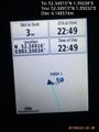
Proof. @52.3491,1.3503

Achievements
Expeditions and Plans
| 2015-06-24 | ||
|---|---|---|
| Canberra, Australia | 1PE | In the south-west corner of the Kowen Forest pine plantation, that is in th... |
| Wien, Austria | Datschech | in a cropfield near Korneuburg |
| Mannheim, Germany | DODO | On a forestial path between Speyer and Iggelheim. |
| Kassel, Germany | GeorgDerReisende | The hash lay on the side of the Dörnberg hill next to the village Dörnberg.... |
| Norwich, United Kingdom | Sourcerer | In a field north of Little Whittingham Green, Suffolk, UK. |
Sourcerer's Expedition Links
2015-06-16 52 0 - 2015-06-24 52 1 - 2015-06-25 52 1 - KML file download of Sourcerer's expeditions for use with Google Earth.