2015-09-03 51 0
From Geohashing
Revision as of 14:34, 3 September 2015 by imported>Sourcerer (→Achievements)
| Thu 3 Sep 2015 in 51,0: 51.7331961, 0.6424850 geohashing.info google osm bing/os kml crox |
Location
In a field, east of Curling Tye Green, Essex, UK.
Participants
Plans
Sourcerer is visiting east Kent in Canterbury, United Kingdom. This is close to the route. ETA 11 am or perhaps noon.
Expedition
- No access. Ploughing in progress. -- Sourcerer (talk) @51.7329,.6426 12:59, 3 September 2015 (GMT+01:00)
Photos

Closest approach. @51.7329,.6426
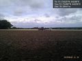
Tractor and plough at hashpoint. @51.7329,.6426


Achievements
Expeditions and Plans
| 2015-09-03 | ||
|---|---|---|
| Portland, Oregon | Michael5000, Jim | On a street in the 60s, just north of the Banfield. |
| Mannheim, Germany | Tads | Almost on top of the Melibokus hill, in a wood close to Alsbach-Hähnlein. |
| London East, United Kingdom | Sourcerer | 2) In a field, east of Curling Tye Green, Essex, UK - placed.smarting.stitching... |
| Norwich, United Kingdom | Sourcerer | 1) erase.buzz.shame = a field south of Horsey Wind pump, Norfolk, UK. |
Sourcerer's Expedition Links
2015-09-03 52 1 - 2015-09-03 51 0 - 2015-09-04 51 1 - KML file download of Sourcerer's expeditions for use with Google Earth.