2016-04-10 52 1
| Sun 10 Apr 2016 in Norwich, UK: 52.3151779, 1.6118037 geohashing.info google osm bing/os kml crox |
Location
Between two footpaths, south of the estuary and east of Blythburgh, Suffolk, UK.
Participants
Plans
Two of two spanning midnight - 2016-04-09 52 1 - 2016-04-10 52 1 - ETA 00:00.
Expedition - Fail
This one was not so easy. I lost the, initially promising footpath and had to scale a barbed wire fence where I tore the seat out of my pants. These were due for replacement so this was no great loss. Sadly there was no one around to see the ungainly disentanglement from the wire and the comedy underpants!
The hashpoint was under water in a reed bed. I attempted to reach it from both sides of the pool but chickened out. In high summer with the possibility of washing off the mud in the estuary I might have attempted it. At midnight with frosty starlight, it didn't seem such a good idea.
There were nice views of the floodlit church at Blythburgh and water fowl were calling and splashing close by.
Photos
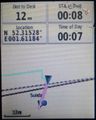
Proof of Fail
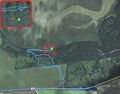
Google Earth Track


Achievements
Expeditions and Plans
| 2016-04-10 | ||
|---|---|---|
| Arroyito, Argentina | Onicofago, Juan | In a soybean field near Rio Primero. Córdoba, Argentina. |
| Bratislava, Slovakia | RecentlyChanged | North east of Bratislava, about one hour drive with the car. |
| Mannheim, Germany | DODO | Next to a path in the forest near Walldorf. |
| Kassel, Germany | GeorgDerReisende | The hash was on the Mühlenberg (mill hill) east of Heiligenrode. |
| Norwich, United Kingdom | Sourcerer | Between two footpaths, south of the estuary and east of Blythburgh, Suffolk... |
| Manchester, United Kingdom | Claire | 53.315°, 2.612° A field in Daresbury |
Sourcerer's Expedition Links
2016-04-09 52 1 - 2016-04-10 52 1 - 2016-04-11 52 1 - KML file download of Sourcerer's expeditions for use with Google Earth.