2016-05-21 51 13
| Sat 21 May 2016 in Dresden: 51.0365641, 13.6168378 geohashing.info google osm bing/os kml crox |
Location
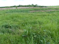
Today's location is in a meadow next to the Autobahn A17, at the Dresden city limit.
Country: Germany; state: Sachsen (Saxony, EU:DE:SN); district: Dresden; Ortschaft: Gompitz
Weather: sunny, warm
Expedition
Danatar
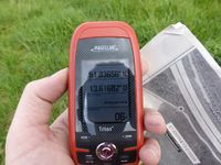
This hashpoint was a welcome opportunity to both reach another Saturday meetup hashpoint and have some exercise in the sun. At around 15:15 I started to cycle through Dresden, first through the city center and then along streets towards the southwest city limit. The street past the city districts Wölfnitz and Gorbitz (Kesselsdorfer Straße) was leading uphill for a long while and this part of the route was feeling awefully long. Meetup time was ticking closer and closer and still there was no end in sight. Finally I reached the intersection where I would have to cross the Autobahn. I cycled past allotment gardens and finally I reached the hashmeadow at 4 pm. It took me a bit of GPS dancing to find the correct spot, but then I was finally able to catch a breath, wipe the stinging sweat out of my eyes and sit in the sun for a while. The noise from the Autobahn marred the moment. Nobody else showed up. After a while I started the return journey. Now I was able to reap the benefits of that long uphill road, shooting downhill for a long while (though interrupted by lots of red lights). At 5 pm I was back at home.
|
Camera was still on winter time.


