2024-07-27 -37 145
| Sat 27 Jul 2024 in -37,145: -37.8086992, 145.7211272 geohashing.info google osm bing/os kml crox |
Location
About 300 m off Britannia Creek Road, Yarra Ranges.
Participants
Plans
<Here are my plans.>
Expedition
Britannia Creek Road is a beautiful cycling destination and a regular feature on my gravel adventures. I was by no means confident that the hash was close enough to the road to be feasible, but I was nonetheless quite happy to have an excuse to head up that way on a gloomy Saturday morning. After a leisurely start to the day (coffee in bed), my tyres were pumped and I set off up Old Warburton Rd, then on to Mount Bride Road. After about an hour of uphill slog, I enjoyed the roll down the back of the Bride to Britannia Creek Rd. Pausing for a snack, I noticed with concern that Ian is lost in the woods, so resolved to keep an eye out for the poor hound.
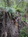
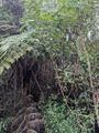
A fun feature of Britannia Creek Rd from the Mt Bride side is a Strava segment called "Roller Coaster Thriller", which reaches a maximum gradient of -20%. Thrilling indeed as the road ahead becomes verrry narrow at high speed... Soon after the roller coaster, one reaches a sweeping 180 degree bend which provided the closest approach to the hash. So I paused to contemplate the situation. The ground was reasonably flat towards the hash, but there was also an enticing deer path just off the corner of the road, so I stashed my bike behind a bush (hash stash for bush bash?) and proceeded on foot. The deer path soon petered out and I proceeded along a fallen tree trunk for a few more metres.
After taking about half an hour to travel 100 m, I decided to quit with 200 m more to go. The terrain was only getting harder and more impenetrable. There was no sign of Ian and I had no desire to end up like him, with my furry face on a sad poster nailed to a tree. In confirmation of my wisdom, back at the road it started to rain as I picked three leeches off various parts of my body. With token raincoat on I rolled on down into Wesburn and back home along the Warburton trail, sodden but intact for future adventures.
Photos

217 m short of the hash...
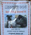
Good boy!
For scale, this is ~1.5 m in diameter, but slippery as a greased bush pig.
217 m thataway...


Achievements
Sourcerer earned the Water geohash achievement
|