2024-10-19 -37 144
| Sat 19 Oct 2024 in -37,144: -37.6029640, 144.9752861 geohashing.info google osm bing/os kml crox |
Location
On Cragieburn Rd East, Wollert
Participants
Expedition
I woke up and saw where the hash was, on a busy road right on the northern edge of Melbourne's suburbia. Not the most appealing usually, but the Galada Tamboore cycle path takes you to within about 20m of the hash. How convenient! Also, October was running out and I had yet to hash for the month. I had plans later in the day, but I had time in the morning. I had to go for it. It was a bit of a ride, but I could easily get the train back from Cragieburn.
I set off, and rather than following cycle paths the whole way I took a more direct route across Essendon, Pascoe Vale and Hadfield to reach the ring road cycle path. I followed this for a bit, crossed over the ring road itself on the overpass provided, then turned left to join the Galada Tamboore path. I then rode along this. I saw some pretty relaxed looking kangaroos, though the longer I lingered, taking a couple of photos, the more concerned they became. I put their minds at rest by continuing on my way.
When I was getting closer, the path suddenly came to an abrupt halt. Some kind of track works ahead. Fortunately they had set up an alternative path that ran alongside the usual one, but this one was all gravelly which was a bit annoying compared to the nice paving I had got used to. I was also concerned that I may be led away from the point that the path approached the hash the closest. Luckily, I was reunited with the one true path in time, and before I knew it, I was at Cragieburn Rd East. I left my bike against a fence, and surveyed the road.
Hmmm. Quite busy. Not a lot of gaps. But after a while I was able to get out to the point and grab a gps screenshot. A bit later I made a second excursion onto the road for a selfie. With my hashly duties done, I decided that, rather than following this unpleasant road directly back to Cragieburn for a train, I would continue up the bike path to its end a few K north of Cragieburn, whence I could follow a different path back down to Cragieburn. So I did this.
I hadn't checked the frequency of trains leaving Cragieburn at lunchtime on a Saturday, but a 7 minute wait for a train seemed pretty good to me. I got off at Moonee Ponds, sped down the Holmes Rd hill, and rode home along the River. I arrived home satisfied from a good hash, but my main regret was that, due to the section under repairs, I hadn't really ridden the the entirety of the Galada Tamboore path. That'll have to wait for another day (another hash).
Photos

Kangaroos
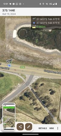
GPS proof

Success


Achievements
Johnwrw earned the Bicycle geohash achievement
|
John earned the Constant geohasher achievement
|