2008-09-20 34 -106
| Sat 20 Sep 2008 in 34,-106: 34.5939233, -106.8365649 geohashing.info google osm bing/os kml crox |
Plan
Bishop_Wash: Today's location was closer to us in the graticule to the south. The hash was close to a street according to Google maps. Therefore, my wife and I thought it would be obtainable and headed off with our dog in tow. We arrived at the site at 1630. The last few miles to the site were on a one-lane dirt road. As we got close to the hash, we passed a windsock in a pull-off from the road. When I was perpendicular to the coordinates, I pulled off to the side of the road and noticed a van pulling into the windsock pull-off.
The hash was 500 feet from the road. It was a quick walk across an open field to the coordinates. As we were zeroing in on the coordinates and getting a picture of the GPS unit, I noticed parachutes in the sky to the north. The windsock pull-off was a landing zone for the local skydiving company. It would have been great to parachute onto a hash. Is that an achievement ribbon? After taking a few pictures on the skydivers, us and our dog, we headed back to Albuquerque.
Pictures
- 2008-09-20 34 -106-GPS.JPG
GPS reading

My wife and I at the location
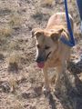
Our lovable lab
- 2008-09-20 34 -106-Skydivers.jpg
Skydiver landing zone nearby

