2008-11-23 49 10
From Geohashing
Revision as of 16:19, 23 November 2008 by imported>Danatar (New page: {{meetup graticule | map=<map lat="49" lon="10" date="2008-11-23" /> | lat=49 | lon=10 | date=2008-11-23 | graticule_name=Bamberg | graticule_link=Bamberg, Germany }}__NOTOC__ == Location ...)
| Sun 23 Nov 2008 in Bamberg: 49.6929728, 10.0818286 geohashing.info google osm bing/os kml crox |
Location
Today's location is in a field with young corn between Erlach and Zeubelried, near Ochsenfurt.
Expedition
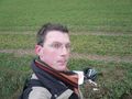
Danatar
I cycled along the Main to Sommerhausen, then up the steep slope to Erlach. Near the hashpoint, it took me some minutes to reach the spot because I didn't want to trample the young corn, I finally used the lines left by the tractor's tires. I hoped for my thermometer to drop below 0, but it didn't. Then I went back.
It's another bicycle geohash with a total distance of 24 km + 21.3 km = 45.3 km according to Google Maps.
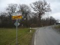
Erlach town sign
Coordinates reached
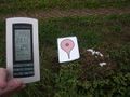
Temperature went down to 1.6°C over the next minutes.


