Cambridge, United Kingdom
| - | - | - |
| Northampton | Cambridge | Norwich |
| London West | London East | - |
[[Category:Meetup in {{{lat}}} {{{lon}}}| ]]
This graticule has boundaries from 52° to 53° latitude, and 0° to 1° longitude and contains Cambridge, UK. The graticle from -1° to 0° longitude is also near to Cambridge, but, due to the symmetry about the prime meridian, will never provide locations closer to the centre of Cambridge.
Local Geohashers
- Slainveteran is bike powered, so will only be able to make it when the coordinates lie nearby Cambridge itself
- lilac is also bike powered, but might be prepared to cycle up to about ten miles for a Saturday location.
- Spanky is also bike powered from Cambridge, and generally will try to go on a Saturday. Limit of about 15 miles and prepared to take a train to get in range. Suggests: some cunning way of indicating who has visited a spot...?
- youpi is bike powered.
- JPD is bike powered as well. 16:00 is usually Not A Good Time, but will occasionally get there before that and leave a mark.
- Ax has a new bike and might try a long distance cycle ride if the weather is nice any time soon... and is occasionally car powered.
- Keeper is powered by caffeine and petrol; therefore, he can get most places.
- murphy is bike powered until his more petrol based bike is fixed, after which he can get most places.
- Granularman will most likely put in an appearance on 7 June, before he disappears to far-off graticules. He is powered by car and determination.
- TheCoop is bike powered from cambridge.
8/6
Depending on the weather Ax might try and cycle to this one, any idea how long a 15 mile cycle at a pleasurable pace might take?
Ax: at a pleasurable pace you might take about an hour to an hour and a half.
(Consider pleasurable cycling to be around 15mph as this is fast enough to feel the breeze, not too slow to be dull. That's an hour. Then add half an hour for stops at traffic lights (if you do that sort of thing), and anything uphill which might be around 10-12mph.)
7/6
This week's location is in a field just off Manea Road (B1093) near March. Granularman and his sidekicks will be aiming to take the train to March, and cycle the 5-6 miles from there.
Spanky will likely do something similar. Trains get in to March at 15:35 and 16:35. Spanky will either be early or late. This is the way of things.
Spanky was late, getting there around 17.30. Saw nobody. The way of things was observed*. Did anybody else go? Couldn't find any markers.
*except by the GPS, which did a covert 'recalculation' and added 3 miles to the journey.
Granularman and co. were in the vicinity from about 16:45 to 17:15, enjoyed the Stone Age fort nearby, and left a small chalked epigram beside the road.
31/5
The new location is in a field near Safron Waldon 15 miles from Cambridge, cycle-able if its nice weather. 2008-05-31 Cambridge, United Kingdom
25/5
For the cycle-powered, Sunday's location (2008-05-25) looks to be reachable from Bishops Stortford / Stansted Airport railway stations (though it's about 10 miles each way):
51.9417748528,0.18287359767
Mmm, it looks like there is a mistake above: it is *not* in the (52,0) graticule...
- True, but the (52,0) location is further from Cambridge, and significantly more underwater.
Did anybody go on Sunday?
24/5
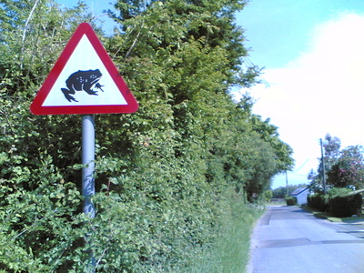
- Youpi was there (52.126648°, 0.547533°) this afternoon (Saturday, 24/5) between 16:00 and 16:30 but saw nobody :/ Anyway it was a cool 46 miles tour! On the way I spotted an unexpected road sign:
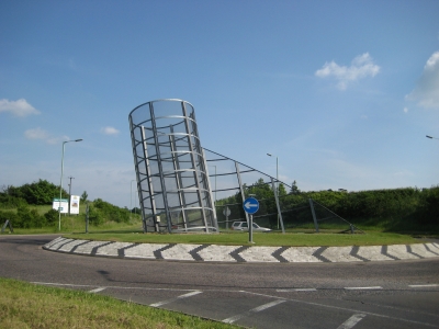
- Spanky went Saturday (24/5), leaving a little later than expected. Saw nobody and will be taking a satnav in future. Here is an Art found outside Haverhill:
Mini Geohashing
A new idea for the bike-powered. To get a location always close to the centre of Cambridge, try mini-geohashing over an area 1% of a standard graticule.
Method: find your current coordinates and remove everything after the first decimal place. In Cambridge, that's going to be either 52.1 or 52.2 north and 0.0 or 0.1 east. Then add the standard string of digits to the end of the number.
E.g. the geohash coordinates for Sunday 25th May 2008 in the standard graticule are 52.941774°, 0.182873°. That makes the mini-geohash location closest to the centre of Cambridge 52.1941774°, 0.1182873° - much more convenient
What do you think? - Sarah
- I like it in principle, but I think we risk diluting an already-small number of people. A good coverage of Cambridge would seem to be 52.15° + 0.1 x, 0.1° + 0.1 y. Also, if there's a convenient hash every day, it would make it significantly less special when the numbers happen to work out. Perhaps only on Saturdays (and maybe only when the usual hash lands outside of the (52.15, 0.1) - (52.25, 0.2) box)? What do other people think? - Richard

