2009-02-11 49 10
| Wed 11 Feb 2009 in Bamberg: 49.8650157, 10.1767613 geohashing.info google osm bing/os kml crox |
Location
Today's location is at the side of a track in a vineyard near Volkach. It's inside the Volkacher Mainschleife (Volkach Main loop) on the slope directly above the borough Escherndorf, at an elevation of about 255 metres.
Country: Germany; state: Bayern (Bavaria, EU:DE:BY); administrative region: Unterfranken; district: Kitzingen
Weather: Würzburg, 9 am: cold, clouded, single snowflakes; Hashpoint, 10 am: snowfall, 2°C; Volkach, 10:30 am: clouded; Hashpoint again, 11:30 am: sunny, some clouds.
Expedition
Danatar
I started at 8:53 and used a route I had never used before, through Estenfeld and Kürnach. It went very well and I reached the hashpoint at 10 o'clock sharp. Shortly before I arrived there, the clouds became darker and it started to snow. I built a snowman and took pictures, then I continued to Volkach. In Volkach, I cycled for a while up and down the old town's streets before returning to the hashpoint. By then, the snowfall had stopped and the sun had come out. My snowman had completely disappeared, not even a heap of wet snow was left (wtf?? I suspect a crime!). I took more photos, then I cycled home.
I had planned to take a different route to check out possible tracks for future expeditions, but I soon was stopped by a muddy track. Because it would have taken me forever to follow that track, I stayed on the paved road even though that meant a detour. At the prophete bike outlet, I bought some spare parts, including a new odometer/speedometer because the old one (old=4 months) doesn't work anymore. At 13:13 I arrived back home.
This is my second Snowman Geohash, I cycled 56.6 km (home-hp 21.6 km; hp-Volkach-hp 8.7 km; hp-home 26.3 km) (and about 370 m uphill).
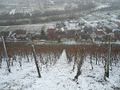
Looking down the slope from the hashpoint
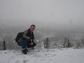
Coordinates reached by snowman
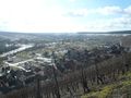
Escherndorf
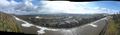
Left: Vogelsburg monastery, track to Volkach; center: Nordheim on the other side of the Main, Eschersdorf on this side
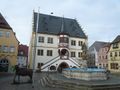
Volkach town hall


