2009-06-27 30 -95
From Geohashing
Revision as of 20:20, 28 June 2009 by imported>DCat22 (New page: {{meetup graticule | map=<map lat="30" lon="-95" date="2009-06-27" /> | lat=30 | lon=-95 | date=2009-06-27 }} On June 27, DCat22 was pilot in command of a flight for sight...)
| Sat 27 Jun 2009 in 30,-95: 30.0192602, -95.5136594 geohashing.info google osm bing/os kml crox |
On June 27, DCat22 was pilot in command of a flight for sightseeing the Houston downtown skyline at night. On the way back to KDWH we were crossing near the geohash point...however, we unfortunately did not capture the coordinates picture when we were within 10 seconds. Aircraft is a private Diamond DA20.
Next time!
Pictures
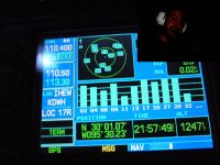
Photo of the geohash location
- Error creating thumbnail: Unable to save thumbnail to destination
Outside view
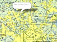
Sectional aviation map view

