2009-08-16 48 11
| Sun 16 Aug 2009 in München, Germany: 48.8929070, 11.8161114 geohashing.info google osm bing/os kml crox |
Expedition
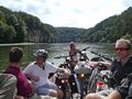
The hashpoint happened to be in Stausacker, south of the "Weltenburg Narrows" near Weltenburg. That was an excellent location for an all day sunday-bicycle trip. dawidi, Hans, Manfred and Tomcat rode to Kelheim, where they visited the famous "Hall of Liberation" [1], took some pictures and found a geocache before they cycled on to Stausacker where the hashpoint turned out to be just 3m behind a fence of a private property. Also here the usual pictures were taken before we took the ferry from Stausacker to Weltenburg and had lunch at the famous Weltenburg Abbey [2]. After that we walked on the hill behind the abbey and visited some more or less interesting archaeological sites before we passed the "Weltenburg Narrows" [3] with our bikes on a tiny boat and returned to Regensburg. The ride back was interrupted by the search for another geocache and a break in Bad Abbach where we had some coffee and icecream.
Photos

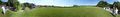
panoramic view at the Hall of Liberation above Kelheim

coordinates reached
360°+ panoramic view at the hash
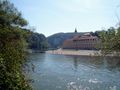
Weltenburg Abbey
on the way back through the Weltenburg Narrows


