2009-09-15 48 9
From Geohashing
Revision as of 19:59, 15 September 2009 by imported>Ekorren (→Gallery)
| Tue 15 Sep 2009 in 48,9: 48.4057106, 9.1249051 geohashing.info google osm bing/os kml crox |
Contents
Location
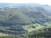
Near Mössingen-Öschingen, in the forest on the very steep slope to the Meisenbühl mountain. There might even be cliffs. You would probably need a helicopter or a chainsaw to actually reach the point.
By bike it's about 17 km from Tübingen, buses go at least once per hour from Mössingen and Reutlingen to Öschingen.
Participants
ekorren got as close as 60 metres.


