2010-03-13 -19 146
From Geohashing
Revision as of 22:07, 12 March 2010 by imported>Mattyk (Created page with '{{meetup graticule | lat=-19 | lon=146 | date=2010-03-13 }} ==Location== 500m off the Flinders Highway, half way to Charters Towers. ==Matty K's Plan== [[File…')
| Sat 13 Mar 2010 in -19,146: -19.8458133, 146.6716763 geohashing.info google osm bing/os kml crox |
Location
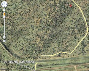
500m off the Flinders Highway, half way to Charters Towers.
Matty K's Plan
Some time this morning we're going to head out that way, and see how it looks. Thanks to Google Maps I've located a potential dirt track that may lead from the highway, cutting 9/10ths of the off-road journey (see image inset); hopefully making it much easier with my 1¾ and 3½ year olds.
Check back in a few hours to see what went down.
