2010-06-14 40 -111
| Thu 27 May 2010 in 40,-111: 40.1332887, -111.4123639 geohashing.info google osm bing/os kml crox |
Location
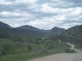
At the top of a ridge in Parley's Canyon. However, it was closer to Emigration canyon.
Expedition
If anyone ever complies a list of the most epic judgment lapses in someone's life, this journey would make that list.
As with all record-breaking adventures, there were several simply stupid moments which added together to create a monumentally idiotic whole:
First: I noticed that a trail went almost all the way up to the point and scheduled two hours for the hike.
Second: I decided to use the hike as a substitute for my run and accordingly wore my gym shorts and shirt.
Third: The point was at the top of a freaking mountain.
Fourth: My car was parked in a publicly challenged area.
Getting up there was the easiest part of the journey. It took maybe a little more than half an hour, the directions were easy enough to follow, and the path I had found which would take me to the top was clear and defined. There was even a small parking area for hikers and joggers wanting to use the trail. Despite having this thought proven wrong again and again every time I geohash, this looked to be easy.
I should have realized something was wrong from the minute I stepped on the trail. Grass and small trees had overgrown everything and there were at the beginning points where I could not tell the trail from the forest around it. But I was not going to let this trip add another failed geohash to my dismal record, so I jogged up the mountain for perhaps a mile more.
Then things got interesting.
The trail led to a narrow stream which it then turned and followed. It was fairly open on my side of the water, but too soon the trees closed in and began to overhand the trail. I was ducking branches and jumping over fallen logs every five feet and was making little headway. This added to the fact that every tree was decorated with gossamer streamers hanging silently to the ground started to make the trip seem a little bit more hellish with every step. I had a big fear of large bugs of all sorts, especially spiders.
I was soon stopping every few moments to steel myself for the next dive. I was traveling the now invisible trail in sudden spurts, trying to get through the sticky undergrowth as quickly as possible then brushing everything off of me. Most of what I threw to the ground were small caterpillars, and it didn't take me long to convince myself that all the sticky threads were were the beginnings of their cocoons. I was still jittery, however, and I began to notice that the bushes around me were rustling and moving.
This was very disturbing, and stopping to try and find the source of the movement I found the ground littered with thousands of large dung beetles, crawling up the trees and all over each other in a mad frenzy. This was getting just a little too weird. But I pushed onward, getting slapped by branches, dive-bombed by caterpillars, and swarmed by beetles. Something wasn't going right with this trail.
After a mile of this, the trail disappeared entirely and the river was squeezed into a small ravine. Now I could not go further without wading the river. I was not going back, but I didn't think I could strip down any further than I was. Wearing shorts and going barefoot through a forest full of beetles and kamikaze caterpillars was not in my realm of possibility. So I did the next best thing: I went straight up the mountain.
To understand my logic, you have to understand the topography of a mountain. Imagine a large pyramid representing a mountain. The top would be the peak and the four sides would make up the base. Submit this shape to erosion to wear out the sharp edges, then add snow-melt and spring-born rivers. This water carves deep channels in the side of the mountain, giving the climber a shallow slope but always keeping him lower than his surroundings. You can never see where you are going and the undergrowth is always thick. This shallowly sloping ravine is what I had been hiking. But I knew that on the sides of these ravines were always ridges which rose above the rivers and were usually the quickest--if hardest--way to the top. It was for one of these ridges that I scrambled, and it was a steep climb.
It took me the better part of an hour to scale the slope of the ravine and make it to the top. My legs and chest were scratched up, but were only bleeding a bit. Once on the ridge, there were no trees and the ground was covered in low sagebrush. This was much better country to hike through, and I could easily see the peak I was headed for from the ridge. Despite having no trail, the going was relatively easy, if steep.
I climbed up the ridge for perhaps an hour before reaching a smaller peak on the ridge where I could stop for a bit. I only had one last steep ascent to the top, and I realized that this one would not be as easy as the last few. It was covered with head-high brush and brambles, and I was wearing jogging shorts and a gym shirt. But I had made it this far. I could continue.
I did it in one big push. I set myself a steady pace and started up. I followed animal trails as much as I could, but when I could not, I forged my own. The grade was steep, and more than once I lost my footing, but every time I caught myself on the branches, and though my hands were bloody, I still was able to get up again. I climbed for what seemed like an hour but was closer to half that. I had set myself a fast clip, and made it to the top just as the sun was setting. And when I broke free of the brush and emerged scratched and bruised on top, I felt as if the entire grueling ascent had been worth it. I could see the canyons on both sides of the mountain, as well as the brightly lit city below me, spread out like a vast mural set before a calm and reflective lake.
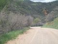
As the sun set, I looked for the exact coordinates of the hash. They weren't that far from the top of the ridge. At least, they didn't seem that way on my GPS. In reality, I had to hike back down the opposite side of the mountain in order to find the point, and the light was failing. I had neglected to bring a flashlight, so I was scrambling down as quick as I could in order to make it to the point quick enough to be able to read my own location. It took me almost half an hour of scrambling back downhill in order to reach the right point. But reach it I did. I was cold, I was shivering, and my cut legs hurt like anything, but I dutifully took a picture of the canyon from the hash and climbed back up to the crest.
When I reached the crest the second time, the sun had set completely and the moon was out. I could see it rise above the lake, and I quickly snapped a picture. The wind was picking up though, and I had no coat, so I quickly started down the mountain again. It would be a long and hateful trip back.
By this time, I was sick of the mountain and wanted to be back somewhere warm. So not caring about the fact that I was wearing very little, I threw myself down the mountain and was almost running down its side. I felt the branches cutting at my legs and arms but I ignored them. I made it down through the brambles guarding the summit in half the time it took me to go up, and before an hour was up was halfway down the ridge. Unfortunately, it was at this time that I got an unexpected call.
"Hello?"
"Hello, can we speak to J______?"
"Speaking."
"This is the Unified Police Department. We are calling about an abandoned Toyota Camry up Emigration canyon. Do you know anything about this situation?"
--TO BE CONTINUED--
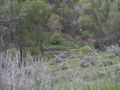
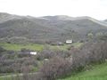
If you squint, you will notice the stream is dammed
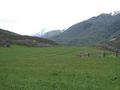
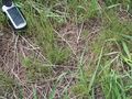
The Point
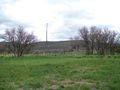
Take From the Point


