2010-07-13 53 -116
From Geohashing
Revision as of 18:47, 14 July 2010 by imported>B cereus (→Photos)
| Tue 13 Jul 2010 in 53,-116: 53.7297663, -116.8136431 geohashing.info google osm bing/os kml crox |
Location
In the forest north of the city of Edson. An area mostly used for forestry, and the oil and gas industries.
Participants
Plans
Working at a rig within 10 km from the coordinates, so I'll grab this on the way to Edson for groceries.
Expedition
I'll get to this soon.
Photos
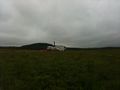
My truck parked at a producing wellhead 1.2 km NE of the hash.
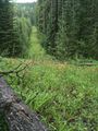
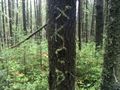
Luckily I found a seismic cutline I didn't notice on Google maps.
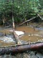
Surprise! A creek!
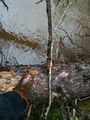
I'm very glad I brought my safety rubber boots.
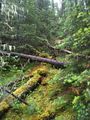
A slippery slope.
- 2010-07-13 53 -116 07.JPG
iPhone evidence, the metadata of pictures now on the iPhone show gps coordinates, but it doesn't transfer onto the wiki for some reason.
- 2010-07-13 53 -116 08.JPG
The patterns made by selective forestry when viewed from satellite are pretty cool.
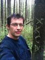
SMILE
The internet was here!


B cereus earned the Land geohash achievement
|