Location
In the forest near Hermsdorf.
Participants
Expedition
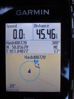
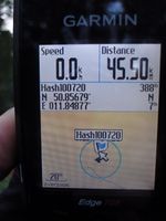
After work I felt like having a nice bike trip while the sun was setting. The 50 11 hashpoint was conveniently close and looked reachable in a forest not too far from paths and roads. By taking some smaller detours I reached the hashpoint area around 20:15. First, I had to use a gravel path through the forest for some hundred meters, then I was continuing on a smaller path for few meters. When I got closer to the spot I saw that there was a fenced area (rather for animal or plant protection than because of private property) which seemed to include the exact coordinates. I stepped right beside the fence and was still 17 m away. Then I walked around one edge of the fenced area and along the other side and suddenly the position marker on the display of my GPS device drifted towards the hash marker. I quickly took a photo, when the distance was only 7 m and the hash marker within the circle of GPS accuracy, and continued watching the drifting arrow. It didn't get closer, but due to this within-10-m rule I think, I can take this hashpoint as being reached. When I turned around to get back to my bike, I saw that I was standing in blueberry bushes and ate three or four delicious berries. Then I cycled back to Jena, ending the trip after 77 km shortly after the sun had set.
Photos
| Crossing motorway A9 close to the hashpoint.
|
| Think, I can't get closer ...
|
| At the other edge of the fence I could at least come closer as GPS accuracy to the hashpoint.
|
|


