2010-08-09 27 84
| Mon 9 Aug 2010 in 27,84: 27.8145734, 84.8604294 geohashing.info google osm bing/os kml crox |
The Place
60kms to the west of Kathmandu, Nepal.
Who Went
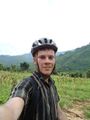
- Felix Dance - by mountain bike.
Expedition
Felix Dance
I'd been a bit peeved that after a week in Kathmandu proper, there would be absolutely no attainable geohashes, so when I saw Monday's one 60kms west of the city, I jumped on it as good enough.
I had planned to start at 6am to give me enough time to travel the 120kms to the hash and back before the monsoonal rains began in the evening. Unfortunately, the monsoonal rains had already started by then, so I had to wait until 10am before it was dry enough to get on my bike (when it rains here it REALLY rains). Unfortunately, again, my rear tyre was flat, costing valuable minutes repairing it.
But soon I was on my way. After the nutcase hard slog up out of the Kathmandu Valley, I soon found myself with spectacular views of the next vally - and about two hours of solid downhill cycling (fun!) - at one point it occurred to me that I'll have to climb back out of this thing at some stage, but quickly dismissed it as being in 'The Future'.
But man, it was HOT. Really really hot. I was sweating like crazy and had to reapply suncream every 20 minutes. I'm not looking forward to the weather when I take my bike onto the Gangetic Plains - it's here at 1500m altitude.
Estimated total ride: 65 kms
Closest approach: 4pm
Total time for geohash: about 9 hours.
Photos
- 2010 08 09 28 84 vilage.JPG
Village near the hash
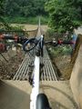
Crossing the bridge

GPS
Felix 500m from the hash


