2010-08-16 50 -113
| Mon 16 Aug 2010 in 50,-113: 50.1611331, -113.6865967 geohashing.info google osm bing/os kml crox |
Location
Somewhere along the side of Range Road 280 in southern Alberta, in the SE Calgary graticule.
Participants
Expedition
The drive was pretty straightforward - I didn't even take a map. I just headed south through Calgary, south on Highway 2, and passed a series of small and large-ish towns along the way (including Nanton, advertising its candy store). At around Stavely, I turned west on Highway 527, and promptly proceeded to drive past the turnoff to Range Road 280. Highway 527 is a narrow 2-lane highway, so I manouvered my car in something like a 7-point turn and made it onto Range Road 280 safely.
Range Road 280 is a dirt road with no obvious lane barrier, even narrower than Highway 527. As I turned onto it, I pulled out my GPS and started watching the coordinates. I overshot the coordinates and proceeded to do another multi-point turn to turn around. After doing so, I promptly pulled as close to the side of the road as possible, since I saw an oncoming truck. The truck passed without event, which is good since I was worried about some farmer stopping to ask what I was doing on the backroad, and I'm not sure if Alberta farmers would take kindly to an explanation involving the words "I'm from the Internet."
I decided it would be best to walk to the coordinates considering how frequently the GPS jumped around, so I parked again as close to the ditch as I could, and got out. From the Google Maps image, I could tell the hashpoint would be somewhere in the very grassy ditch, and at this point I realized that perhaps sandals were not the best choice of footwear. I cautiously walked into the ditch, over a few more steps, and all of a sudden, I was at the hashpoint! I struggled to get the camera to take a picture of the GPS without glare, and finally got something passable. I took a few more pictures of myself and the area, headed back to the car, and headed back home.
It's too bad I didn't have someone else with me to take pictures, since I saw a few cool things on the drive back. There were eagles, or some other large birds circling the air; there were numerous artefacts of Small-town Alberta, including grasshoppers, grain elevators, and Chinese food restaurants. Mostly though, there was the rolling prairie, which looked quite beautiful in the sunlight. I did, however, get a couple of pictures before turning back onto Highway 2: there were a few llamas just hanging out by an abandoned store, and I took some pictures of Stavely itself. I'm not sure if the convenience store in Stavely had some sort of squishy-type drink, and I now regret checking. I also realized, on the drive back home, that I never marked the hashpoint; somehow I don't think another geohasher will be showing up today.
Overall, a pretty easy geohash, although the driving took a while. And of course, I had cherries with dinner to celebrate my success.
Photos

GPS proof!
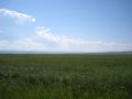
View from the hashpoint.

air384 attempts a Stupid Grin(TM).

Perhaps this grin is less stupid?

Panoramic!
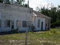
Llamas! Didn't pet them though...
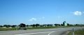
The nearest town.
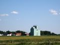
Quintessential small-town Alberta: grain elevators!


