2010-08-19 44 -67
| Thu 19 Aug 2010 in 44,-67: 44.9086657, -67.7931696 geohashing.info google osm bing/os kml crox |
Location
In the woods less than a mile off Route 9
Participants
Plans
The family has been up here in Maine all week on vacation and I've been checking the local hashes every day, but between plans and poor locations we haven't been able to get to one. I checked again this morning and saw that the neighboring Machias hash wasn't too far off the highway, and was a reasonable drive to get there, so we decided to go for it.
Expedition
The drive up went quickly, and the boys weren't too unruly, so other than missing the turnoff for the tiny dirt road (twice!), it was a snap to get there. I was a little worried that the road would be gated closed and posted, but it was open so we drove on back. I parked at a fork in the road and set off on my own because I knew I wasn't going to get the boys back there if I had to bushwhack. I went a short distance down the road, then headed off up a clearcut that someone had made. That ended up taking me within a few feet of the hash, so I really didn't have to do a whole lot of bushwhacking anyway. Yay!
Track
Track located here.
Pictures
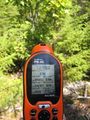
GPS coordinates
- 2010-08-19 44 -67 - grin.jpg.jpg
Me grinning
