2010-09-17 34 -106
From Geohashing
Revision as of 22:18, 3 October 2010 by imported>Redaragorn (Created page with '{{meetup graticule | lat=34 | lon=-106 | date=2010-09-17 }} == Location == On the upper slopes of David Canyon in the Manzanita Mountains, on Cibola National Forest land. == …')
| Fri 17 Sep 2010 in 34,-106: 34.9597949, -106.3629625 geohashing.info google osm bing/os kml crox |
Location
On the upper slopes of David Canyon in the Manzanita Mountains, on Cibola National Forest land.
Participants
- Redaragorn and 20 month old son
Plans
Expedition
Track
The track is located here.
Pictures
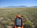
GPS coordinates
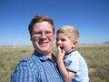
Grin with the boy.
- 2010-10-01 34 -106 - picnic.jpg
Lunch at the hash.

