2010-10-17 53 9

| Sun 17 Oct 2010 in 53,9: 53.6340020, 9.8707579 geohashing.info google osm bing/os kml crox |
Location
According to Google Earth, on a field just outside a residential area. According to my GPS, right inside someone's house... But i'll get to that!
Participants
Planning
This was planned as the second hash in an attempt to get a Consecutive geohash achievement. The conditions were great, the pair of hashes being on a Saturday and Sunday and relatively close to the city. We decided to get rental bikes for this one, but we had a rough start. Let's just say almost half a bottle of Ingwerschnaps (which is ginger liquor, but try and say Ingwerschnaps, especially if you're a native English speaker—it sounds hilarious!) is one of the less ideal things to be drinking the night before you attempt an early geohash.
Expedition

We set out on the rented bicycles and gleefully followed my GPS's instruction. I had just gotten a kickass pocket belt, so I could reach my GPS and my camera while cycling with a minumum of fiddling. I remembered to set the routing algorithm of my GPS from "Car" to "Bicycle", which only a short time later I regretted.
The OpenStreetMap volunteers in Hamburg seem to have a peculiar sense of humor when it comes to the definition of "Footway/Path", and we were lucky to get the bikes through the near-swamp my GPS navigated us through. We were lucky to get the bikes through, because I'm certain the bicycle renting terminals don't have a button labelled "We lost one or more of our bikes in a marsh because we blindly followed our GPS while geohashing."

After a few more "paths" of the maybe-a-dog-runs-by-here-every-month-or-so sort, we finally came along a very nice path alongside a creek. The ride was taking longer than expected, and sometimes I got confused by all the "Follow footway/path to footway/path" message on my GP, but all in all, we got by very well. We passed a very nice lake we decided to check out in the summer. I drew many puzzled looks from the way I studied my GPS while riding, occasionally glancing at the road to compare OSM with RL and circumnavigating all the pesky children permeating the forest.

We then came through something extremely German: A Schrebergartensiedlung, which is a collection of teeny-tiny garden properties with boring little houses, kept in perfect order and neat separation from each other by grumpy old German men with Absolutely Nothing Better To Do. Besides the hedges, which are so meticulously trimmed you might think they used lasers for it, you have little street signs, perfect lawns and dozens of signs forbidding every activity on earth except being a grumpy old German man in a teeny-tiny garden.
Tracklog
Tracklog in GPX 1.1 format (XML Document) accessible in a pastebin.ca post. It looks funny to play it back and see how we went really fast when we were on the metro on our way back.
Photos
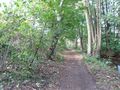
Many bikers here, as popular a route as it is beautiful!

Achievements
mtu and seamus_d earned the Land geohash achievement
|
mtu and seamus_d earned the Bicycle geohash achievement
|
mtu and seamus_d earned the Consecutive geohash achievement
|