2011-07-26 53 -1
| Tue 26 Jul 2011 in 53,-1: 53.4899497, -1.4334210 geohashing.info google osm bing/os kml crox |
Location
Tree-lined field edge, a field near Hoyland and Elsecar, nr Barnsley.
Participants
Plans
Having visited the previous day, after work, to see where the spot might be, the scouting mission was to be repeated with additional pushing through undergrowth. It happened to be much later in the day than anticipated, but that's how it goes.
Expedition
A brief diversion (not too much more than required by some local roadworks due to gas-main improvements) meant that the journey home from work passed by Burying Lane and the car was parked at the end of a public footpath.
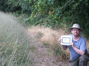
A short walk up this trail, and an unsigned but obviously well-used cut-through led into the field alongside which the hashpoint exists. With the crop and the bordering 'verge' plants being very high indeed, it was a slightly awkward walk along the side of the field, but there were signs of others having been that way before me. Taking care to avoid damaging harvestable crops, however, the way was made through to the tree-shaded edge where the point itself lay. By striding along this area, and comparing this with the overhead photos, the No Batteries identification of the point was accomplished (and even if just missed, passed through at least twice in the process) and the culminating (if pretty unimpressive photos) were taken.
Tracking back to the car, the next stop was to fill up with fuel, given that the plans for the next day would require extensive travel. I find that the price of petrol's gone up again. (About 3 pence per litre more than last time I filled up.)
Tracklog
No log.
Photos
(Photos other than the title photo are still to be uploaded.)
Achievements
TBA. Probably "Land" and "No Batteries" alone, though.
