Adelaide South, Australia
|
Upcoming Coordinates and Map Quick-Links- North | |
|---|---|
| Wednesday 2024-12-18 | -34.1295012, 138.7614786 |
|
Upcoming Coordinates and Map Quick-Links- South | |
|---|---|
| Wednesday 2024-12-18 | -35.1295012, 138.7614786 |

Adelaide
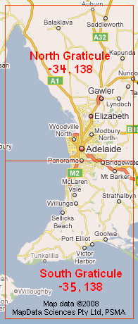
Located on the split of (-34,138) and (-35,138), Adelaide is the capital of South Australia. Due to the splits, the graticules also contain a number of surrounding towns on the both north and south of the city. Roughly 50% of the combined graticules is land, with the graticule used for meet ups will be the one closest to the CBD where possible.
Graticule Links
Completed Geohashes
Template:Virgin graticuleTemplate:Virgin graticuleTemplate:Virgin graticule 2008-05-24 -35 138 - Southern suburbs near Morphett Vale
2008-06-12 -34 138 - Northern graticule, just off coast near Osborne
2008-06-14 -34 139 - North eastern graticule, near Birdwood
2008-06-16 -34 138 - Northern graticule, near Munno Para
2008-06-20 -34 139 - North eastern graticule, close to Tungkillo
2008-06-21 -34 138 - Northern graticule, in Lower Mitcham
2008-08-08 -35 138 - Southern suburbs, between Flagstaff Hill and Bellevue Heights
2008-09-10 -35 138 - Southern Graticule near the old Port Willunga Jetty
2008-09-18 -35 138 - Southern Graticule, on the Salisbury Highway.