2012-03-26 41 -80
| Mon 26 Mar 2012 in 41,-80: 41.1278934, -80.0496628 geohashing.info google osm bing/os kml crox |
Location
Near Grove City
Participants
- Nsnyder 21:41, 26 March 2012 (EDT)
Plans
Expedition
Operation Virgin Geohash
I set out, with only my running shoes and trusty Droid Incredible as my GPS, to be the first to claim a geohash in the Youngstown, Ohio location. As I set out, I ran along the road, climbed onto the train tracks, and approached my goal. I looked on in determination as it became apparent that I must cross a swamp in order to reach the location. Google maps had obscured this fact by showing me the woods. Still, I pressed on. I climbed down the hill and sloshed through the swamp, careful not to drop my Droid Incredible as I went. Finally, I crossed the large swamp and then a smaller marsh and reached the field. From then, it was only a matter of locating the location in the field. Embedded is the proof. I realize that I forgot the date, but rest assured, as I upload this on March 26, I have claimed the graticule. The first to claim Youngstown, Ohio!
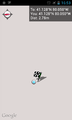
(The distance to location is 2.78 meters, well within the margin of error for the GPS)
Tracklog
Photos
GPS

The Geohasher


Achievements
Nathan Snyder earned the Land geohash achievement
|
Nsnyder earned the Walk geohash Achievement
|