2012-05-02 40 -105
| Wed 2 May 2012 in 40,-105: 40.8486950, -105.4953380 geohashing.info google osm bing/os kml crox |
Location
In a field just south of Prairie Divide Road, about 6 miles northeast of Red Feather Lakes, CO
Participants
Plans
Since coming across this wiki at the beginning of April, I've been checking the hash points periodically, hoping that one would fall conveniently near my home or work so I could give geohashing a try. Well, I guess was just in the mood for going on an adventure this day (which, in retrospect, seems much more in line with the "spirit" of geohashing than waiting for a convenient spot to come up), since this hash point wasn't really nearby at all, but for whatever reason, I decided to go for it. This random spot seemed like it would be a nice place to try and reach, it was a warm and mostly sunny afternoon, so why not take a little trip to a location that I wouldn't otherwise have had a reason to visit? I checked the county parcel locator to see if the hash point was on private property, found that it was in fact on public US Forest Service land, and resolved to go there that evening.
My planned route was to head north out of Fort Collins on US 287, turn west on Cherokee Park Road (county road 80C), then head south on Prairie Divide Road (for some reason, labelled as both county road 19 and 179 on Google Maps). The hash point would be near a little dirt trail just south of Prairie Divide Road. After reaching the hash point, I then planned to continue south on Prairie Divide Road, turn east on Red Feather Lakes Road (county road 74E), and head south on US 287 to return home.
Expedition
Though it had been a warm and sunny afternoon when I decided to go for this hash, by the time evening rolled around, it had become mostly cloudy and windy with scattered rain showers around. Undeterred, I simply added an umbrella to the pile of things I was bringing along, and set out at about 6:20 PM. After stopping for gas on the way out of town, I headed north on US 287 as planned and turned west onto Cherokee Park Road. This was a nicely-maintained, wide dirt road winding through rolling rangeland and occasional larger hills. I passed lots of cattle grazing in the surrounding fields, though I also came upon a few cattle grazing right at the edge of the road! Somehow, they had managed to push up the bottom wire of a wire fence high enough so that they could squeeze under it, and three of them had made their "escape" to the strip of grass between the fence and the road. I slowed down so as not to alarm them, but they were apparently much more interested in munching grass than in examining passing vehicles, because they didn't move or even look up from their meal as I drove past. I also came upon two groups of deer during the drive, one group which simply looked up as I went by, and another which became quite distressed by my approach and ran over a hill away from the road.
Photos
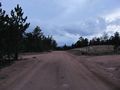
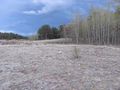
The main road near the hash point
The side road that led toward the hash point
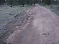
The side road was a tad uneven...
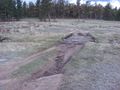
Then it became a pile of logs atop a mud pit
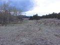
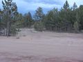
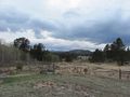
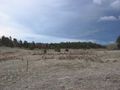
The hash point should be in this field...
There it is!
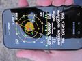
The proof

My Stupid Grin™
The view to the west-southwest from the hash point

The view to the north-northwest
The view to the east
- Error creating thumbnail: Unable to save thumbnail to destination
A mysterious pool of water
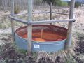
A mysterious rusty, empty pool
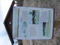
An informative sign about a former mine near the hash point

Proof of the date for land geohash achievement


Achievements
Squenes earned the Land geohash achievement
|