2013-02-26 56 -2
From Geohashing
Revision as of 19:33, 26 February 2013 by imported>Wasindear (→Plans)
| Tue 26 Feb 2013 in 56,-2: 56.2350292, -2.6707214 geohashing.info google osm bing/os kml crox |
Location
Next to the sea, in a muddy field with pigs in.
Participants
Plans
Wasindear's plan was to cycle from St Andrew's to the location. Though it was hatched on a whim.
Expedition
Wasindear's plan was mostly successful, but he had to dismount for the final bit, as the field was far to muddy to allow for cycling.
Tracklog
Wasindear has no tracklog. Mostly due to not having know about tracklogs before setting out.
Photos

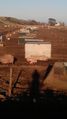
Wasindear and his bike relax after a tiring journey.

Darn it, those pigs beat me to the location, and it looks like they intend to stay overnight.
Also they are cute.


Achievements