2013-03-10 49 -122
| Sun 10 Mar 2013 in 49,-122: 49.0379557, -122.8232070 geohashing.info google osm bing/os kml crox |
Location
A wooded corner of a public park in White Rock.
Participants
- Wade
- Robyn
- Arbron
Plans
We will head out here in the afternoon, leaving downtown Vancouver around one p.m. on a motorcycle, putting us at the geohash around two p.m.
Expedition
Wade and Robyn
It started at 2:00 am, when Wade failed to set the clocks back an hour. At 8:00 PST, Wade woke up realized that he had about 50 minutes before he needed to leave for church, and started to read his email. At 8:10 PST, Wade realized that it was actually 9:10 PDT, and he was supposed to have left 20 minutes ago. At 9:15 PDT, Wade rushed out of the house with no geohashing equipment. Speed limits were broken in the attempt to get to church no later than he already was, but since he would get divine forgiveness at the end of the trip, Wade figured it's all OK.
After church, Robyn met Wade and his friends for brunch. The original plan was to go straight from brunch to the hash-point, but since Wade had rushed out without a GPS or clothign appropiate for possibe bush-whacking, they returned home to properly equip themselves for the journey.
Photos
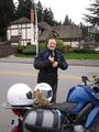
Wade and T-Rex on the bike
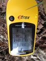
We're here

Specifically T-Rex is on the spot

Anyone coming later will know they are not alone


