2014-05-29 51 14
| Thu 29 May 2014 in Cottbus: 51.0348536, 14.1316679 geohashing.info google osm bing/os kml crox |
Location
Today's location is in a rapeseed field near Langenwolmsdorf, a part of Stolpen.
Country: Germany; state: Sachsen (Saxony, EU:DE:SN); district: Sächsische Schweiz-Osterzgebirge
Weather: clouded, sometimes light rain
Expedition
Danatar
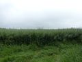
Because of Ascension Day I didn't have to work. At first I wanted to visit this hashpoint by bike, but the rainy weather convinced me to take the bus. At 14:30 I cycled to the nearest bus stop of the 261 line, on the northern end of the Waldschlösschen bridge. The bus ride was uneventful and I passed most of it reading a magazine, sometimes looking out of the window. I got off at Langenwolmsdorf while there was no rain, but the rain started again while I walked on the side of the road towards the hashpoint. On the way I passed a group that was hiking with a toy wagon, a common view on Ascension Day in Germany, since Fathers' Day is on the same day and people use the holiday to get drunk. The spot itself lay in a rapeseed field, the plants were about chest high for me. As it was a large field, I was still more than 100 meters from the spot and I didn't see any tire tracks in the field. Walking 100 meters through chest-high wet stuff, in the rain and with no possibility to avoid destroying the crops, I decided to mark this hashpoint down as "not reached".
I tried to walk along another side of the field, but it was the same from that side, although I found beehives. Then I walked back to Langenwolmsdorf. I had almost 1.5 hours until the next bus and I didn't want to sit at the bus stop for such a long time, so I walked to Stolpen, the next city. It took me about 50 minutes to reach Stolpen Castle, where I climbed on some towers, took a look at the exhibits and watched guys in historic uniforms set up camp for a historic re-enactment that was planned for the following weekend. At 5 p.m. I took the bus back to Dresden.
In total, I walked 6.1 km and used public transport for 50.2 km. Getting to and from the bus stop by bike was 4.6 km.
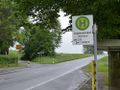
bus stop
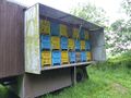
beehives
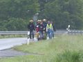
a Vatertag hiking group with a 'Bollerwagen'
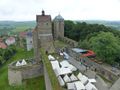
Stolpen Castle
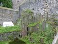
columnar basalt makes up the castle hill
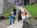
re-enactors in uniform

Countess of Cosel's grave


