2014-08-09 50 11
| Sat 9 Aug 2014 in 50,11: 50.9899008, 11.6287656 geohashing.info google osm bing/os kml crox |
Location
In the woods near Neuengönna.
Participants
Plans
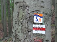
I plan to walk there, leaving Jena at Nordfriedhof/Munketal and following first the red trail markings and then the Saalehorizontale to Neuengönna. From there I'll just follow my GPS.
Expedition
As planned, I left at 1, cursing myself for not doing this in the morning when it was cooler. Luckily, after maybe half an hour of walking, it became a bit cloudy and windy, which made everything more pleasant.
As planned, I followed first the red trail markings, which belong to a 100 km trail circumnavigating Jena; then I followed the Saalehorizontale, a scenic trail connecting Jena and several smaller villages. I know this route from Jena to Neuengönna pretty well, so the only noteworthy thing on the way were the many mushrooms which too old already for harvesting, pity.
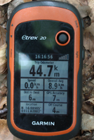
Except when passing through, I had never been in the woods around Neuengönna, so this was new to me and I just followed the directions from my GPS. The spot was a very ordinary spot in the woods, nothing exciting. I had to dance around a bit to get a halfway decent proof of location shot because the reception under the tree cover was atrocious.
On the way back I just walked to Porstendorf and took the train back to Jena,because I didn't have the time to walk back.
Tracklog
Photos
|
Achievements
ScepticAnna (talk) earned the Walk geohash Achievement
|


