2015-01-04 47 -122
From Geohashing
Revision as of 21:54, 4 January 2015 by imported>Thomcat ([live picture] [http://www.openstreetmap.org/?lat=47.56980926&lon=-122.28619039&zoom=16&layers=B000FTF @47.5698,-122.2862])
| Sun 4 Jan 2015 in Seattle: 47.5701305, -122.2877733 geohashing.info google osm bing/os kml crox |
Location
An alley just north of Rainier Square Plaza in south Seattle, near the Charlestown Hill Climb.
Participants
Plans
Flexible; mid-day perhaps? Also need to find out if Charlestown refers to a street or neighborhood name, for tale-of-two-hashes purposes.
- I think it's pretty clearly the Charlestown *street* hillclimb - see the street name immediately south of the hashpoint, which runs right into the steps (and continues east of them after a brief interruption...) -- OtherJack (talk) 12:47, 2 January 2015 (EST)
Expedition
Tracklog
Photos
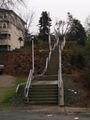
Hill climb @47.5698,-122.2873
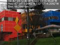
Lovely primary colors @47.5697,-122.2873


Achievements