2015-03-21 66 25
From Geohashing
Revision as of 17:34, 21 March 2015 by imported>Isopekka (Created page with " thumb|left {{meetup graticule | lat=66 | lon=25 | date=2015-03-21 }} == Location == In Rovaniemi, in the middle of a road. ...")
| Sat 21 Mar 2015 in 66,25: 66.5471080, 25.8640241 geohashing.info google osm bing/os kml crox |
Contents
Location
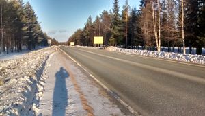
In Rovaniemi, in the middle of a road.
Participants
Expedition
- Driving total 16 km
- Walking total 1.4 km
- Expedition took 1 h
- Physical effort (1-5): 1
Expedition started about at 4:50 p.m. The hashpoint situated in the middle of the highway E75 about 8 kilometers from my home. I found a good parking place at Santa Claus Village. From Santa Claus Village I walked 700 meters to the hashpoint.
Photos
Achievements
isopekka earned the Land geohash achievement
|
Geohashing Expeditions and Plans on This Day
Expeditions and Plans
| 2015-03-21 | ||
|---|---|---|
| Newark, New Jersey | Jevanyn | Starview Dr., in a neighborhood north of Flemington. |
| Mannheim, Germany | Q-Owl, Q-Owla | Near Wald-Michelbach in the Odenwald. |
| Frankfurt am Main, Germany | Yakamoz, Rincewind | located in a forest near Nieder-Bessingen. |
| Kassel, Germany | GeorgDerReisende | The hash lay on the edge of a field near Elliehausen. |
| Rovaniemi, Finland | isopekka | In Rovaniemi, in the middle of a road. |


